
Patagonian Andes
Patagonian Andes Between Puerto Aisén and Río Pascua (Including the Northern Patagonian Ice Field) (Lat 45°30' to 48°S.)
Only on Landsat images (Paths, Rows 248-92, 248-93, and 248-94; table 8) can one appreciate the large number of glaciers that are present in the region. On the images, it is possible to distinguish the following:
- A relatively straight line of ice-capped mountain groups extending approximately along the 73°W. meridian, including mainly:
- Nevado Cóndor, 1,960 m (lat 45°37'S.) (fig. 25)
- An apparent, large, circular caldera (centered on lat 45°55'S.), 10 km in diameter, filled with ice, Cerro (Volcán) Hudson. From the caldera's ice field, a heavily debris-covered outlet glacier flows to the northwest more than 12 km to Río Huemules (fig. 25). Note that in 1971, 5 years before this image was made, Cerro (Volcán) Hudson had a very big explosive eruption
- Another ice field of the same size that has 20 outlet glaciers at lat 46°08'S. The main outlet glacier, 2 km wide, flows to the northwest (fig. 25)
- Seven other unnamed mountain groups extending to the mouth of Río Baker (the outlet of Lago Buenos Aires/General Carrera) at lat 47°50'S. (see figs. 26, 27).
- East of Río Baker, between Lago Buenos Aires/General Carrera and Lago San Martín/O'Higgins to the south, lies a wide belt of glacierized mountains that is dissected into many groups (southeast quadrant of figs. 26, 27, and 28). The mountains extend into Argentina, where Bertone (1960) completed a preliminary glacier inventory. The main glacierized mountain is Cerro San Lorenzo (3,700 m, lat 47°36'S., long 72°19'W.) on the international border (east of fig. 26). (See maps in Buscaini and Metzeltin, 1989, p. 190 and p. 192). It has three large glaciers, all debris covered on their lower parts. The west, 12-km-long glacier (in Chile) shows little evidence of retreat, whereas the south (12-km-long) and east (8-km-long) glaciers (both in Argentina) are situated well below their lateral moraines.
- West of the central line of mountains, the Northern Patagonian Ice Field (NPIF, called in Spanish, Hielo Patagónico Norte) covers about 4,200 km2 (figs. 26, 27, 28). Most of the NPIF is a plateau 1,100 to 1,500 m in elevation. The plateau extends 90 km from north to south and 30 km from east to west, and it is crossed by a northwest-trending range (Cordón Aisén). Thirty outlet glaciers discharge from this ice field [Editor's note: Aniya (1988) inventoried 28 outlet glaciers from the NPIF]. The main glaciers from the northern part of the ice field are two that flow to the west: Glaciar San Rafael (the lowest latitude tidewater glacier in the world) and Glaciar San Quintín (the largest outlet from NPIF that ends in a piedmont lobe), and two glaciers that flow to the southeast: Glaciar Nef and Glaciar de la Colonia. The main outlet glaciers of the southern part of the ice field are Glaciar Benito and three unnamed glaciers that flow to the west (HPN 1 to 3), Glaciar Steffen and Glaciares Pared (Norte and Sur) that flow to the south, and Glaciar Arenales that flows to the east, where it merges with Glaciar de la Colonia.

|

|

|
Figure 25.--Part of a Landsat 2 MSS image of the Wet Andes north of Lago Buenos Aires/General Carrera showing Monte Macá, Nevado Cóndor, and two ice fields that have outlet glaciers.
|
Figure 26.--Landsat 5 MSS false-color composite image mosaic of the Northern Patagonian Ice Field.
|
Figure 27.--Northern Patagonian Ice Field (green).
|
The equilibrium line altitude (ELA) on Glaciar San Rafael was at 1,050 m in December 1952 (Club Andino Bariloche, 1954) and at 1,200 m in October 1994 (Rignot and others, 1996b). On Glaciar Soler on the east side of the NPIF, Aniya and Naruse (1987) found the ELA at 1,350 m.
Ice thickness has been determined by using gravimetry along an east-west traverse at about lat 46°52'S. (Casassa, 1987). The surface lowers westward progressively from 1,511 m to 1,111 m over 21.85 km, whereas the bed elevation ranges irregularly between +596 m and -223 m, and the thickness ranges between 620 m and 1,458 m.
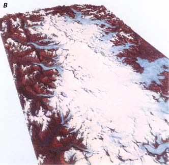
Figure 28.--Perspective views of the Northern Patagonian Ice Field.
A, Perspective view from the southeast showing the trace of Cordón Aisén across the ice field.
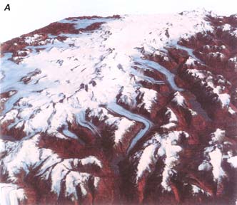
B, Perspective view from the northeast. In the foreground is Monte San Valentín (compare with fig. 41A). The views were created by draping Landsat 5 MSS images of 9 February 1987 (51075-13514; Path 232, Row 92; 51075-13520; Path 232, Row 93) over a digital-elevation model. Courtesy of Masamu Aniya, Institute of Geoscience, University of Tsukuba, Ibaraki, Japan.
U.S. Geological Survey, U.S.Department of the Interior
This page is https://pubs.usgs.gov/prof/p1386i/chile-arg/wet/northpat.html
Contact: Richard S. Williams, Jr., and Jane G. Ferrigno
Last modified 04.06.99