GLACIERS OF SOUTH AMERICA--
GLACIERS OF COLOMBIA
By FABIAN HOYOS-PATIÑO 1
Snowfields and glaciers in Colombia are limited to the highest peaks and ranges in the Cordillera Central and Cordillera Oriental and above the 4,700-meter elevation on the Sierra Nevada de Santa Marta. The total area of snowfields and glaciers was estimated to be about 104 square kilometers in the early 1970's.
Historical, geographical, and pictorial records point toward a consistent and progressive depletion of ice-and-snow masses in the Colombian Andes since the end of the "Little Ice Age" in the late 1800's. Many glaciers have disappeared during the 20th century, and others are expected to disappear in the coming decades.
The northernmost extent of the Andes Mountains consists of three branches in southern Colombia (fig. 1). The branches are known from west to east as the Cordillera Occidental2, Cordillera Central, and Cordillera Oriental. The Cordillera Oriental continues into Venezuela, where it is called the Cordillera de Mérida (Mérida Andes) (see subchapter I-1, "Glaciers of Venezuela"). The Sierra Nevada de Santa Marta, a huge tetrahedral-shaped massif that is detached from the Cordillera Central, rises as an isolated mountain near the Caribbean coast. Two relatively small coastal ranges, the Serranía de Baudó, bordering the northern Pacific coast, and the Serranía de San Jacinto, rising from the Caribbean lowlands, do not belong to the Andes Mountains either geologically or geographically.
Two large rivers, the Río Cauca and the Río Magdalena, divide the three cordilleras. The cordilleras are bordered by extensive coastal lowlands on the north, large plains on the east, and a complex landscape of alluvial plains and valleys, tidal flats, and the Serranía de Baudó on the west. Snowfields and glaciers are restricted to the highest peaks and ranges of the Cordillera Central, Cordillera Oriental, and Sierra Nevada de Santa Marta.
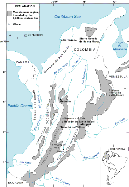
Figure 1.--Location of glaciers in Colombia. Mountains are delineated by the 2,000-m contour line (heavy dark line).
Glacier phenomena have not received widespread attention in Colombia in the past because of geographic, economic, and cultural reasons. The ordinary layman generally has not been aware of the importance of snow-and-ice masses, either as natural-resource assets or as potential hazards. Water is taken for granted, and geologic hazards, especially if located in remote and poorly known areas, were generally ignored before the catastrophic eruption of the glacier-clad Nevado del Ruiz in 1985, which produced several major lahars (mudflows caused by volcanic activity). However, arid and semiarid lands depend on the nearby snow-covered mountain ranges for their water supply. Even in humid regions, glaciers act as gigantic reservoirs that regulate seasonal water flow in their respective drainage basins.
The juxtaposition of glaciers and active volcanoes, as well as glaciers and earthquakes, poses a significant geologic hazard that can produce jökulhlaups (outburst floods) and (or) lahars and (or) debris avalanches. Examples are the 1985 eruption of Nevado del Ruiz and the earthquake-generated ice-and-debris avalanche from the Nevados Huascarán massif in Perú that buried the village of Yungay (see subchapter I-4, "Glaciers of Perú"). These types of events have been documented by Acosta (1846) in the 19th century, as well as more recently with respect to the devastation wrought in November 1985 by the volcanic activity of Nevado del Ruiz, a large volcano surmounted by an ice cap (Smithsonian Institution, 1985; Herd and Comité de Estudios Vulcanológicos, 1986; Jordan and Mojica, 1988; Williams, 1990 a, b; Finsterwalder, 1991; Mileti and others, 1991; and Thouret, n.d.). The lahars associated with the Nevado del Ruiz eruption were deemed to be the deadliest ever recorded, as the death toll was estimated to be as much as 23,000 (probably several thousand more if undocumented migrant workers were included), and most of Armero, a city of about 25,000, disappeared under a huge mudflow.
In June 1994, an avalanche originating in the Nevado del Huila took a toll of at least 1,500 lives and destroyed hundreds of dwellings, tens of bridges, and kilometers of roads in the basin of the Río Páez. This avalanche was unleashed from the glacierized area of the Nevado del Huila and from the steep slopes of the upper Río Páez basin by an earthquake of Richter magnitude 6.2.
The study of snowfields, glaciers, and related features in Colombia has drawn the attention of several scientists, including geologists and geographers (Fuchs, 1958; Lehr, 1975). However, the remoteness of most of the snow-and-ice features has prevented, in the past, a systematic study of their physical characteristics and history. A compilation of available information suggests a consistent snowline retreat during the 20th century or since the end of the "Little Ice Age" in the late 1800's. A more extensive snow cover in the mountain massifs in the past is suggested by the common reference to the "sierras nevadas" (snow-covered summits) in the southern part of the country by the conquistadores and in old chronicles cited by Freire (1958). The Sierra Nevada de los Coconucos (4,300-4,850 m; lat 2°16'N., long 76°22'W.) no longer deserves the name nevada, and the Cerro Nevado at the Páramo de Sumapaz (4,300 m) in the Cordillera Oriental south of Bogotá definitely lost its mantle of snow by 1917 and later changed its name. La Piraña (4,600 m), Nevado del Cisne (5,100 m), and Nevado del Quindío (5,120 m), three formerly snowcapped summits in the Ruiz-Tolima massif (Thouret, n.d.), and the Volcán Chiles (4,750 m) and Nevado de Cumbal (4,764 m), two volcanoes near the southern border, cannot be considered nevados any longer, although they still had a snow or firn cover at the beginning of the 20th century and, in some cases, retain ephemeral snow areas. In the case of today's glacierized areas, this trend toward loss of snow cover is very apparent and will be discussed in more detail later. A similar long-term retreat of the snowline and the recession of glaciers throughout the country is corroborated by a comparison of ancient paintings (Mark, 1976) with recent ground and aerial photographs from different dates and by the evaluation of the physical geographic descriptions of the highlands from old documents and reports (Ancízar, 1853; Reiss and Stübel, 1892; Vergara y Velasco, 1892; Stübel and Wolf, 1906; and Freire, 1958).
Subzero-degree temperatures and the high precipitation necessary to produce snow are found in the high mountains near the Equator. Unlike the climate at mid- and high-latitudes, the seasonal temperature varies little; mean daily temperature is nearly constant. At high altitudes, the largest daily variations (maximum to minimum) of about 25°C take place during the diurnal cycle; however, the average daily temperature does not vary more than 2°C throughout the year. Solar radiation also varies only slightly (Guhl, 1983). The 0°C air temperature isotherm altitude is at about 4,800 m, although local variations caused by the orographic setting and cloud cover can be found. At low latitudes, the equilibrium line altitude (ELA) roughly coincides with the 0°C air temperature isotherm altitude, although snowfalls can develop as low as 4,000 m. Local differences in snowline altitude can be explained by the orographic effect on moisture distribution and temperature. Short-term variations in snowline altitude originate within a narrow range and are caused by variations in precipitation rather than in temperature. On the other hand, long-term variations in snowline may be caused by changes in precipitation and temperature associated with changes in either local or global climate. Indicators of the level of snowline during the last glacial maximum in the Colombian Andes, such as moraines, reveal that during the Pleistocene, Colombia had a much more extensively glacierized area. Moraines are found consistently all over the Colombian Andes at 3,800 m; where a sufficient accumulation surface existed, ice reached at least as low as the 3,300-m level during the last advance. An older snowline has been proposed close to the 3,000-m level, and the correlated glacial drift has been observed at least as low as 2,700 m (Coleman, 1935; Oppenheim, 1940, 1942; Raasveldt, 1957; Brunschweiler, 1981; Van der Hammen, 1984; and Helmens, 1990).
Manuscript approved for publication 18 March 1998.
1 Universidad Nacional de Colombia, Apartado Aéreo 1027, Medellín, Colombia.
2 Geographic place-names used in this section conform to the usage recommended by the U.S. Board on Geographic Names (Defense Mapping Agency, 1988) in its Gazetteer of Colombia.
| Home | Next |
U.S. Geological Survey, U.S.Department of the Interior