Landsat Imagery
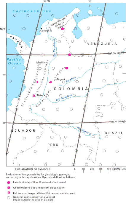
Only a limited number of cloud-free Landsat 1-3 images were acquired of the glacierized areas of Colombia. The best are listed in table 6, and their area of coverage is shown in figure 16. The imagery has been used in this chapter to delineate the areal coverage of ice and snow on the Colombian nevados, but it is difficult to differentiate the snow cover from the glacier areas because of the small size of the Colombian glaciers and the limitation of resolution of the Landsat MSS sensor.
Figure 16.--Optimum Landsat 1, 2, and 3 images of the glaciers of Colombia.

Table 6.--Optimum Landsat 1, 2, and 3 images of the glaciers of Colombia
[See fig. 16 for explanation of symbols used in "Code" column]
|
Path-Row
|
Nominal
scene
center
(lat-long)
|
Landsat
identification
number
|
Date
|
Solar
elevation
angle
(degrees)
|
Code
|
Cloud
cover
(percent)
|
Remarks
|
|
7-55
|
07°13'N.
72°24'W.
|
30306-14262
|
05 Jan 79
|
43
|

|
0
|
Sierra Nevada del Cocuy
|
|
7-56
|
05°47'N.
72°45'W.
|
1179-14373
|
18 Jan 73
|
46
|

|
0
|
Sierra Nevada del Cocuy; image used for figure 7
|
|
8-53
|
10°06'N.
73°10'W.
|
1162-14421
|
01 Jan 73
|
43
|

|
0
|
Sierra Nevada de Santa Marta; image used for figure 4B
|
|
8-53
|
10°06'N.
73°10'W.
|
2716-14170
|
07 Jan 77
|
38
|

|
0
|
Sierra Nevada de Santa Marta
|
|
8-57
|
04°20'N.
74°31'W.
|
2716-14184
|
07 Jan 77
|
41
|

|
10
|
Nevado del Tolima
|
|
9-57
|
04°20'N.
75°57'W.
|
2375-14350
|
01 Feb 76
|
44
|

|
20
|
Nevado del Ruiz-Nevado del Tolima; image used for figure 8B
|
|
9-58
|
02°53'N.
76°17'W.
|
2375-14353
|
01 Feb 76
|
44
|

|
40
|
Sierra Nevada del Huila; image used for figure 15B
|
The mapping and measurements of snow-and-ice areas from Landsat images tend to be less accurate than measurements of glacierized areas made by the use of vertical aerial photography. This is because of the limitations of the Landsat sensor, particularly the difficulty in differentiating snow from ice. However, the Colombian glaciers appear to be receding fairly rapidly, and until new aerial photography is acquired and analyzed of all the glacier areas, this study offers the best comprehensive baseline comparison of the glacierized areas of Colombia. Higher resolution Système Probatoire d'Observation de la Terre (SPOT) images were used by Vandemeulebrouck and others (1993) in their study of tephra and lahar deposits in the vicinity of the ice cap on Nevado del Ruiz (fig. 12). Both the Landsat 4 and 5 Thematic Mapper (TM) images (30-m pixels) and the SPOT images (20-m and 10-m pixels) provide higher resolution images than Landsat MSS images (79-m pixels). These and higher resolution, satellite-imaging systems in the future will slowly replace the aerial photogrammetric methods of mapping ice caps and outlet glaciers.
U.S. Geological Survey, U.S.Department of the Interior
This page is https://pubs.usgs.gov/prof/p1386i/colombia/landsat.html
Contact: Richard S. Williams, Jr., and Jane G. Ferrigno
Last modified 01.24.99


