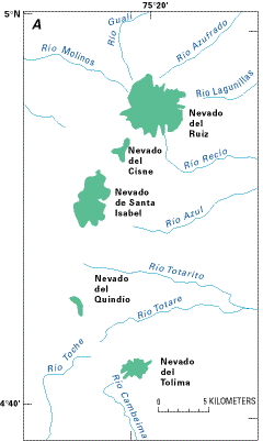
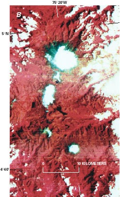
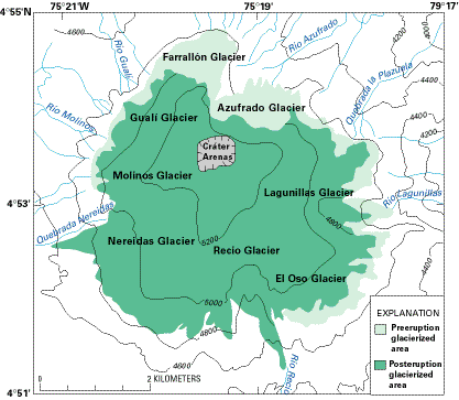
The Ruiz-Tolima volcanic massif comprises five different formerly ice-clad stratovolcanoes ("nevados"): El Ruiz, El Cisne, Santa Isabel, El Quindío, El Tolima (figs. 8, 9). El Cisne and El Quindío have nearly lost their snowfields; their ephemeral snow- and ice-covered areas are barely 1 km2 each. The other three may be classified as mountain ice caps. Figure 8A is a sketch map of the glaciers and snowfields of the Ruiz-Tolima massif drawn from a 1 February 1976 Landsat 2 MSS color-composite image (shown in fig. 8B).
Figure 8.--Glaciers and snowfields of the Ruiz-Tolima volcanic massif. A, Area of glaciers and snowfields, shown in green, calculated from a Landsat 2 MSS image acquired on 1 February 1976. B, Enlargement of northeastern part of Landsat 2 MSS false-color composite image (2375-14350; 1 February 1976; Path 9, Row 57) from the EROS Data Center, Sioux Falls, S. Dak. |
|
|
|
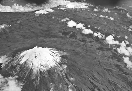
Figure 9.--Oblique aerial photograph looking to the north-northwest across Nevado del Tolima (foreground) towards Nevado de Santa Isabel, Nevado del Ruiz, and Nevado del Cisne in the background. Part of Nevado del Quindío is on the left margin. Photograph courtesy of Instituto Geográfico Augustín Codazzi taken in 1959.
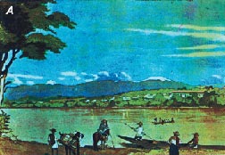
Nevado del Ruiz is the highest and most extensive stratovolcano in this massif (figs. 9, 10, 11). It rises more than 5,300 m above mean sea level and supports an ice cap that had an area of 21.3 km2 measured on a 1976 Landsat image. The snowline is at an altitude of 4,900 m on its west flank and 4,800 m on the east flank. A comparison between 19th century paintings (Mark, 1976) (figs. 10A, B) and a recent photograph (fig. 11) shows an impressive retreat of the margins of the ice cap, which Herd (1982) estimated at 150 m, equivalent to a shrinkage of 64 percent from the area of the ice cap in 1845.
Figure 10.--Nineteenth-century paintings of the Ruiz-Tolima volcano complex by E. Mark. A, Nevado del Ruiz (right), Nevado de Santa Isabel, and Nevado del Tolima (left) are seen from the Magdalena Valley (watercolor painted in 1846). B, Nevado del Ruiz (right) and Nevado del Tolima (left) also seen from the Magdalena Valley (watercolor painted in 1845). Reproduced with the permission of the Biblioteca Luis Angel Arango, Bogotá:, Colombia. |
|
|

|
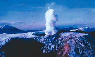
Figure 11.--Ruiz-Tolima massif looking south-southwest in 1986. The active Nevado del Ruiz volcano is in the foreground, the Nevado del Tolima is in the left background and the Nevado de Santa Isabel is in the center background. Photograph courtesy of Ingeominas.
In 1983, the Central Hidroelectrica de Caldas (CHEC) (1983) published a study of geothermal activity in the Nevado del Ruiz volcanic massif. However, in November 1985, Nevado del Ruiz erupted (Sigurdsson and Carey, 1986), and according to Thouret (1990), about 16 percent (4.2 km2) of the surface area of the ice and snow of this nevado was lost, and 25 percent of the remaining ice was fractured and destabilized by earthquakes and explosive volcanic activity. The associated volume decrease was estimated to be approximately 6x10⁷ m3 or 9 percent of the total volume of ice and snow (Thouret, 1990; Williams, 1990a, b); figure 12 illustrates the extent of the ice and snow lost during the 1985 eruption. Glaciological changes have also been analyzed by Jordan and others (1987). A digital, color orthophoto map by Finsterwalder (1991) provides a precise topographic and image baseline for comparison with past and future maps of the glaciological status and extent (area and volume) of the ice cap on Nevado del Ruiz.
Figure 12.--Effect of the November 1985 volcanic eruption on the Nevado del Ruiz ice cap (modified from Thouret, 1990).
Between 1986 and 1995, the average retreat rate of the glacierized area of the Nevado del Ruiz has increased to 3-4 m a-1, which amounts to 20-30 m in elevation, owing to the decrease in albedo associated with the tephra cover deposited during the 1985 volcanic activity. Faster retreat has been noted on individual glaciers. Ramírez and Guarnizo (1994) reported 13 m for the vertical retreat of a single, isolated glacier on the western flank of the glacierized area over the period 1987-1988 and 8.8 m over the period 1990-1991. Linder (1991, 1991/1993), Linder and Jordan (1991), and Linder and others (1994), using aerial photogrammetric methods and digital elevation models, calculated posteruptive loss of ice volume. The figures show that ice loss is continuing at a greater rate than the average preeruption retreat.
El Cisne has a maximum elevation of 5,100 m, and its accumulation area is now so small that it is no longer considered to be a nevado. It supports only ephemeral snowfields.
The Nevado de Santa Isabel rises to 5,110 m above mean sea level and has a snowline at 4,800 m on its west flank and 4,700 m on its east flank. The snow-and-ice cover was measured as 10.8 km2 on a 1976 Landsat image. Since 1986, this nevado has undergone a similar but more moderate increase in loss of its glacierized area compared to the Nevado del Ruiz. In addition, the snowline has risen 10-15 m in the period 1986-1994.
The maximum elevation of El Quindío is 5,120 m above mean sea level. Although above the regional snowline, the accumulation area is so small that it can no longer be considered to be a perennial snowfield.
The highest point on Nevado del Tolima is 5,280 m above mean sea level (fig. 13). Glaciers descend to 4,740 m on the west side of the volcano and to 4,690 m on the east side (Herd, 1982). The area of its ice cap was 3.8 km2 measured on a 1976 Landsat image (fig. 8B). A newly published, digital, color orthophoto map accurately shows the ice cap and outlet glaciers on the summit of Nevado del Tolima (Finsterwalder, 1992).
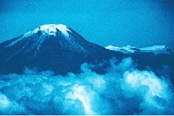
Figure 13.--Nevado del Tolima in the foreground and Nevado de Santa Isabel in the background seen from the southeast. Photograph courtesy of Villegas (1993).
| Home | Next |
U.S. Geological Survey, U.S.Department of the Interior