Vertical aerial photographs of good quality exist for most of the glacierized mountains. (Refer to Hastenrath (1981) and table 3 for a detailed listing of these photographs.) Because the aerial photographs were taken for general survey, not glaciological purposes, and because of the frequent cloud cover in the humid-tropical Ecuadorean Andes, the aerial surveys were flown at the first favorable opportunity. Therefore, most photographs do not record the optimum glacier exposure possible during the cloud-free intervals of the minimum precipitation months (see fig. 2). This, in most cases, makes it more difficult and sometimes impossible to make a good glaciological evaluation from the aerial photographs. In addition, owing to the diurnal precipitation total and the year-round frequent snowfall events, the aerial photographs in many instances show a fresh snowfall, which reveals little in the way of relief contrast. It is, therefore, understandable that the contour lines on maps derived from these photographs can render only a very rough approximation to the actual relief. All these facts make accurate interpretation of glaciologic features from the existing aerial photography very difficult.
Table 3.--Aerial photographs of the glacierized mountains of Ecuador
[Abbreviations: HYCON, JET, Ecuadorean, aerial photographic mission designations; USAF, U.S. Air Force; VM, vertical mapping; PMW, Photo-Mapping Wing; IGM, Instituto Geográfico Militar; AMS, U.S. Army Map Service]
|
Glacier area |
Date |
Photograph identification |
|---|---|---|
|
Cordillera Occidental |
||
|
Cotacachi |
15 Feb 1956 |
HYCON: nos. 124256-124257, 124268-124269 |
|
|
07 Mar 1963 |
USAF: nos. 2637-2638, 2653-2654 |
|
Iliniza |
24 Jun 1962 |
USAF: VM AST-2, 1370 PMW, roll 26, nos. 1855-1856 |
|
|
22 Jun 1963 |
USAF: VM CAST-9, 1370 PMW, roll 52, nos. 4451-4453 |
|
Chimborazo-Carihuairazo |
24 Jun 1962 |
USAF: VM AST-2, 1370 PMW, roll 27, nos. 2048-2050 |
|
|
24 Jun 1962 |
USAF: VM AST-2, 1370 PMW, roll 26, nos. 1878-1884 |
|
|
26 Jun 1962 |
USAF: VM AST-2, 1370 PMW, roll 26, nos. 1946-1949 |
|
|
12 Nov 1963 |
USAF: VM CAST-9, 1370 PMW, roll 71, nos. 6313A-6315A |
|
|
01 Nov 1977 |
Proyecto: Carta Nacional, R-28 IGM, nos. 5542-5544 |
|
|
10 Nov 1977 |
Proyecto: Carta Nacional, R-29 IGM, nos. 5791-5794 |
|
Cordillera Oriental |
||
|
Cayambe |
08 Feb 1965 |
USAF: linea 52A, nos. 7117-7119 |
|
|
08 Feb 1965 |
USAF: linea 54, nos. 7177-7178 |
|
|
17 Feb 1966 |
USAF: linea 56, nos. 7595-7598 |
|
|
31 May 1978 |
Proyecto: Carta Nacional, R-33 IGM, nos. 6763-6765 |
|
Saraurcu |
17 Nov 1966 |
USAF: linea 56, nos. 7601-7602 |
|
|
02 Aug 1978 |
IGM JET: linea 30-D-R-33, nos. 6766, 6782-6783 |
|
Antisana |
16 Feb 1956 |
HYCON: VV, HY, M, 142 AMS 153, linea 538, nos. 124156-124159; linea 539, nos. 124217-124220 |
|
|
07 Feb 1965 |
USAF: VM 1370 PMW, R-76, linea 49, nos. 6730-6732; linea 52, nos. 6711-6714 |
|
|
08 Feb 1965 |
USAF: VM 1370 PMW, R-78, linea 52A, nos. 7102-7104 |
|
|
02 Apr 1977 |
Proyecto: Carta Nacional, R-20 IGM, nos. 3885-3888, 3825-3827 |
|
Sincholagua |
15 Feb 1956 |
HYCON: VV, HY, M, 142 AMS 163, nos. 124289-124292, 124312, 124234 |
|
Cotopaxi |
15 Feb 1956 |
HYCON: VV, HY, M, 142 AMS 163, nos. 124293-124294, 124307-124309 |
|
|
25 Nov 1956 |
HYCON: VV, HY, M, 174 AMS 153, nos. 29767-29768 |
|
|
03 Jan 1976 |
IGM JET: linea R6, nos. 1076-1078 |
|
Quilindaña |
15 Feb 1956 |
HYCON: VV, HY, M, 142 AMS 153, nos. 124295-124297, 124227-124228 |
|
|
01 Feb 1966 |
USAF: VM, 1370 PMW, AF 60-16, R83, nos. 7690-7691 |
|
Cerro Hermoso |
13 Jun 1956 |
HYCON: linea 546, nos. 29652-29653 |
|
|
17 Sep 1976 |
IGM JET linea 1-R-12, nos. 2342-2344; linea 2-R-12, nos. 2353-2355 |
|
Tungurahua |
15 Feb 1956 |
HYCON: linea 541, nos. 29602-29604; linea 542, nos. 29538-29540; linea 543, nos. 29787-29788 |
|
|
04 Apr 1977 |
Proyecto: Carta Nacional, R-21 IGM, nos. 4000-4002 |
|
Altar |
15 Feb 1956 |
HYCON: linea 541, nos. 29595-29599; linea 543, nos. 29543-29545; linea 543, nos. 29792-29793 |
|
|
02 Apr 1977 |
IGM JET: linea 24-R-21, nos. 4004-4011 |
|
|
31 May 1978 |
Proyecto: Carta Nacional, R-33 IGM, nos. 6848-6851 |
|
Cubillín |
22 Apr 1963 |
USAF: linea 44, nos. 4688-4690 |
|
|
04 Apr 1977 |
IGM JET: linea 23-R-21, nos. 4041-4042 |
|
Sangay |
13 Jun 1956 |
HYCON: M-172, nos. 29671-29672 |
|
|
08 Feb 1965 |
USAF: VM, 1370 PMW, AF 60-16, R-77, nos. 6893-6895 |
|
Collay |
15 Feb 1956 |
HYCON: linea 543, nos. 29809-29812 |
|
|
04 Apr 1977 |
IGM JET: linea 22-R-21, nos. 4107-4108; linea 23-R-21, nos. 4028-4031 |
|
Cerro Ayapungo |
15 Feb 1956 |
HYCON: linea 543, nos. 29809-29812 |
|
|
04 Apr 1977 |
IGM JET: linea 22-R-21, nos. 4107-4l08; linea 23-R-21, nos. 4028-4031 |
Optimum Landsat imagery of glacierized areas of Ecuador is listed in table 4 and located in figure 11. These images, namely Landsat multispectral scanner (MSS) images 21474-14323 and 30345-14460, acquired on 4 and 13 February 1979, respectively (figs. 9 and 10), are particularly useful because they are comparatively cloud free. They include the northern and southern parts of the Ecuadorean Andes, respectively. Proceeding from north to south, we will discuss first the Cordillera Occidental and then the Cordillera Oriental with reference to these two satellite images. For more general aspects look also at the section on Bolivia in this volume. In the northern part of the Cordillera Occidental, Cotacachi can be identified on Landsat image 21474-14323 (fig. 9) only a short distance to the north of Laguna Cuicocha. This mountain still carries perennial ice, but it cannot be seen on the satellite image because the glacier area is too small. The mountains Volcán Pichincha and Corazón can be identified in the Quito region. They are not glacierized presently, but perennial ice persisted into the last century. Southward from Corazón lie the twin peaks of Iliniza. The more southerly peak carries an ice cap from which 10 outlet glaciers descend. The mountain appears free of clouds on the satellite image, and the ice cover can be seen with difficulty. The gross morphology of an older moraine system is well depicted.
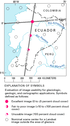
Figure 11.--Optimum Landsat 1, 2, and 3 images of the glaciers of Ecuador.
In the southern part of the Cordillera Occidental lies the highest mountain in Ecuador, Chimborazo (6,310 m), and the neighboring but much lower peak of Carihuairazo (5,020 m) (fig. 10). Both carry ice caps; the former has 22 and the latter, 9 outlet glaciers. The mountains appear nearly free of clouds on Landsat image 30345-14460. The glaciers on Carihuairazo can be seen only on the false-color composite image and not on the black-and-white Landsat image; the glacierization of Chimborazo is conspicuous in both versions. The gross morphology of older moraines on the Chimborazo-Carihuairazo massif can also be recognized on the satellite image.
In the northern part of the Cordillera Oriental, Cayambe is well depicted in figure 9. This mountain carries an ice cap that feeds 20 outlet glaciers. Saraurcu to the southeast is free of clouds on the satellite image and can be seen as a small white point. Antisana is cloud free and has an ice cap that feeds 17 outlet glaciers. The gross features of modern ice extent and older moraine morphology are shown especially well. Sincholagua also appears free of clouds on the satellite image. The mountain carries three small ice fields, but these are not apparent at all on the black-and-white version, and they are only barely visible on the false-color composite version of the satellite image. The gross features of older moraine morphology are, however, very well delineated. The volcanic cone of Cotopaxi is particularly conspicuous on the satellite image. With a summit elevation of 5,911 m, it is considered to be one of the highest active volcanoes on our planet. An ice cap that covers all but a few rock outcrops on the upper part of the mountain feeds 23 outlet glaciers.
Table 4.--Optimum Landsat 1, 2, and 3 images of glaciers of Ecuador
[See fig. 11 for explanation of symbols used in the "code" column]
|
Path-Row |
Nominal scene center (lat-long) |
Landsat identification number |
Date |
Solar elevation angle |
Code |
Cloud cover |
Remarks |
|---|---|---|---|---|---|---|---|
|
10-60 |
00°00'N. |
21474-14323 |
04 Feb 79 |
43 |
|
0 |
Excellent of all glacierized areas |
|
10-61 |
01°26'N. |
30345-14460 |
13 Feb 79 |
47 |
|
60 |
Cloud-free image of glaciers of Quilindaña and Chimborazo-Carihuairazo. Other glaciers partially or completely cloud covered |
|
10-62 |
02°53'S. |
|
|
|
|
|
No cloud-free image available of glaciers of Cerro Ayapungo |
The part of the Cordillera Oriental that lies south of Cotopaxi is covered by figure 10. Quilindaña, which is free of clouds, supports only two small glaciers, but these do not show on the black-and-white image and are only barely visible on the false-color composite version of the satellite image. The area of Cerro Hermoso is obscured by clouds on this image. The small summit ice cap of Tungurahua appears partly obscured by clouds. Altar, the most beautiful mountain of the Ecuadorean Andes, is also partly obscured by clouds. Altar has a caldera that opens toward the west. It is especially heavily glacierized on its eastern flank, where 6 separate outlet glaciers are present, although these are not discernible on the satellite imagery. An additional three ice masses present in the caldera are partially shaded in the satellite images. However, the large caldera lake that formed during the course of this century is visible. Gross features of older moraine morphology can likewise be recognized. The identification of ice and snow on Cubillín is marginal. A cloud sheet on the Amazon side of the cordillera extends to the region of Sangay, so this active, ice-clad volcano cannot be discerned on the satellite imagery. The ice extent on Collay appears to be too small to show on the satellite image, and Cerro Ayapungo lies just south of the image.
Because the 4 February and 13 February 1979 Landsat images provide an excellent record of many of the glaciers, it has been possible to determine the ice surfaces with a greater degree of accuracy than has been the case so far for most of the glacierized regions in Ecuador. Additional certainty has been gained through comparison with the precisely surveyed Cotopaxi glacierization pattern (Jordan, 1983). Table 1, which provides information on the glacierized areas of the Ecuadorean Andes, was based--as far as Chimborazo, Cayambe, Antisana, and Altar, are concerned--on analysis of satellite images using the STEREOCORD, which especially for Cotopaxi, reveals an excellent agreement with the area calculated by means of aerial photogrammetry (3 percent). Further information on this method can be found in papers by Mohl (1980), Jordan and Kresse (1981), and Schwebel and Mohl (1984).
Even though small glaciers cannot be easily identified on Landsat MSS images and are even sometimes hard to identify on Landsat TM and SPOT satellite images with absolute certainty, especially where they appear obscured by clouds, the interpretation of larger ice surfaces (covering more than 0.2 km2 (20 ha) is very accurate. It would even be possible, in case of high-quality, cloud-free imagery, such as the February 1979 data, to distinguish accumulation and ablation areas from each other on larger glaciers and thus make glaciological determinations that are not possible now. The use of high-resolution satellite imagery is especially important for glaciological studies here because no suitable aerial photography exists. Images of Chimborazo, Cayambe, Antisana, and Cotopaxi have been enlarged to scales of about 1:250,000 and 1:200,000 (see figs. 6 and 12) in an attempt to illustrate these applications. Ecuador's characteristic glacier type stands out very clearly on the Landsat images. The ice caps on the compact volcanic cones appear to be round to oval in a flat-surface projection, and the outlet glaciers, which diverge in the ice-free areas downslope, appear as frazzled edges. This special type of continental tropical glacier, an ice cap on the summit of a conical volcano, is suitable, where large enough, for interpretation from satellite imagery. These ice caps are generally less obscured by shadow-casting features, with the exception of the Altar nevado (snowfield), than are marginal tropical glaciers (see the section on the glaciers of Bolivia in this volume). The Landsat images, especially the one of 4 February 1979, would be worth processing digitally by using contrast-enhancement methods. The digitally enhanced images could be used to distinguish more clearly the glacier features and boundaries and to determine glacier areas.
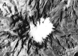
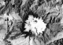
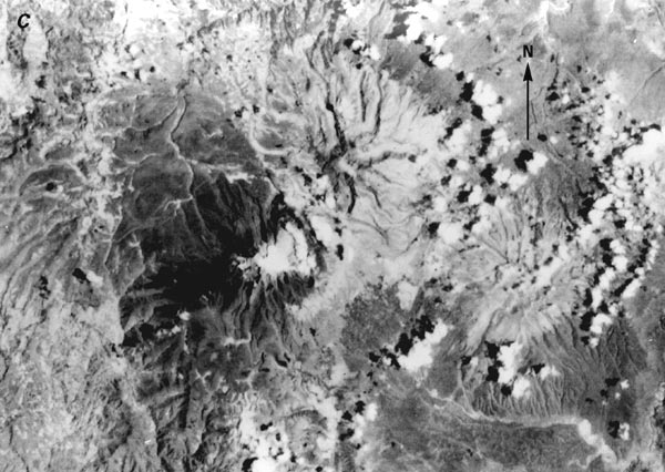
Figure 12.--Parts of Landsat MSS images of volcanoes in Ecuador that have glacier areas greater than 0.2 km2 (20 ha). These images are enlarged to a scale of about 1:200,000 in order to illustrate the typical continental tropical glacier on a volcanic cone. The ice caps have round to oval outlines and lobate edges (outlet glaciers). In some areas, it is possible to separate the accumulation and ablation areas on the glaciers by means of the different gray tones.
A, Cayambe, in the northern part of the Cordillera Oriental, carries an ice cap that feeds 20 outlet glaciers, many of which can be delineated on the image.
B, Antisana, also in the northern part of the Cordillera Oriental, has an ice cap that feeds 17 outlet glaciers. Many of these are visible, in addition to ablation features on the ice cap.
|
|
C, Chimborazo, in the southern part of the Cordillera Occidental, has an ice cap that has 22 outlet glaciers. Clouds obscure some of the glaciers, but the majority are visible. Also visible on the image to the northeast of Chimborazo is Carihuairazo, although its ice cap and nine outlet glaciers cannot be delineated. Figures 12A and 12B are from Landsat image 21474-14323, band 7; 4 February 1979; Path 10, Row 60. Figure 12C is from Landsat image 30345-14460, band 7; 13 February 1979; Path 10, Row 61. Both images are from EROS Data Center, Sioux Falls, S. Dak.
| Home | Next |
U.S. Geological Survey, U.S.Department of the Interior


