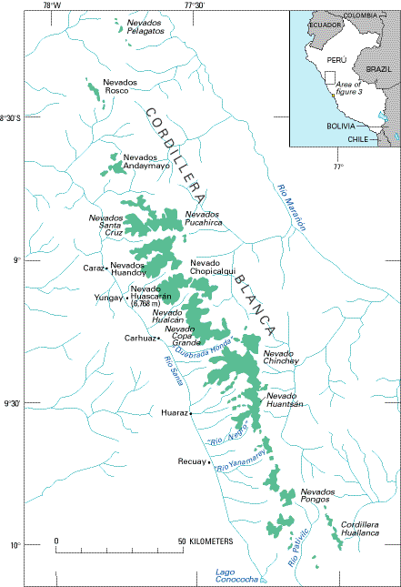
The Cordillera Blanca is the most extensive tropical ice-covered mountain range in the world and has the major ice concentration in Perú. It is part of the Cordillera Occidental and trends in a northwesterly direction for about 200 km between lat 8°08' and 9°58'S. and long 77°00' and 77°52'W. (figs. 2-5). It marks the continental divide; Río Santa on the west drains into the Pacific Ocean, whereas Río Marañón on the east drains into the Atlantic Ocean. The Cordillera Blanca has five of the most spectacular peaks above 6,000 m in the Peruvian Andes. The highest peak (Nevado Huascarán) rises to an elevation of 6,768 m asl. A total of 722 individual glaciers are recognized in the Cordillera Blanca, and these cover an area of 723.4 km2. Most of these glaciers are on the western side of the ranges, where 530 glaciers cover an area of 507.5 km2. On the eastern side are 192 glaciers that cover an area of 215.9 km2; the lowest glacier terminus is at 4,200 m asl. Most of the glaciers, 91 percent of the total, are classified as mountain glaciers; they are generally short and have extremely steep slopes. The rest are classified as valley glaciers, except for one ice cap. Four are similar to rock glaciers (Kinzl, 1935, 1942, 1964; Kinzl and Schneider, 1950; Morales Arnao, C., 1964; Morales Arnao, B., 1969a, b; figs. 3 and 4; tables 1 and 2).
Figure 3.--Distribution of glaciers (shown in green) in the Cordillera Blanca and Cordillera Huallanca. The Cordillera Blanca is the most extensive tropical ice-covered mountain range in the world and has the largest ice concentration in Perú.
By Stefan L. Hastenrath
Figure 4, the best available Landsat 1, 2, or 3 image of the Cordillera Blanca area, provides an excellent pictorial overview of the major glacierized areas. North of the main glacierized segment of the Cordillera Blanca can be seen the ice cover on Nevados Pelagatos and the Nevados Rosco. The great bend of the Río Santa valley (on the left center of the image) broadly marks the northern extremity of the Cordillera Blanca (fig. 4). The gross physiography of the area is dominated by this deep valley, as well as the Cordilleras Negra and Blanca on the west and east, respectively. It is possible to identify the separate glacierized areas on Nevados Andaymayo in the northwestern part of Cordillera Blanca.
Figure 4.--Annotated Landsat 2 MSS false-color composite image (2194-14351; 4 August 1975; Path 8, Row 66) of the northern part of the Cordillera Blanca. Abbreviation: Q., Quebrada. Landsat 2 image from EROS Data Center, Sioux Falls, S. Dak.
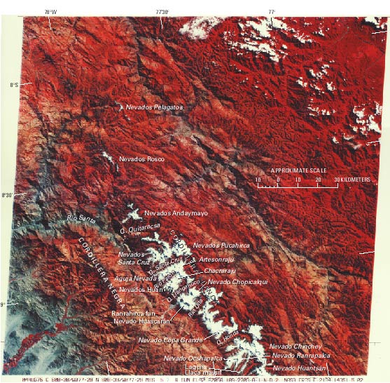
Two tributaries of Río Santa, Quebrada Quitaracsa and Quebrada Santa Cruz, bound the complex glacier system of the Nevados Pucahirca and Nevados Santa Cruz (fig. 4). The Quebrada Santa Cruz valley and Quebrada Llanganuco to the south delineate another glacier system, arranged in horseshoe form around Rio Parón. Within this area are the mountain peaks Aguja Nevada, Artesonraju, Chacraraju, and Nevados Huandoy. These peaks can be seen in the panoramic view shown in figure 5. The Quebrada Llanganuco and the Río Ulta bound the Huascarán massif. The saddle between the north and south peaks of Nevado Huascarán can be seen in figure 4; particularly conspicuous are the scars of the catastrophic Huascarán debris avalanche of May 1970 (Welsch and Kinzl, 1970; Morales Arnao, B., 1971; Plafker and Ericksen, 1978) that originated on the west side of the north peak and completely destroyed the city of Yungay (see figs. 6 and 12).
Figure 5.--Panoramic view in the northern Cordillera Blanca taken from the summit of Nevado Chopicalqui looking from the northwest (left) to the north (right). Photograph by Leigh Ortenburger.
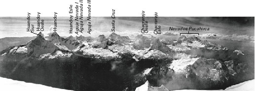
Figure 6.--Oblique aerial photograph of the site of the former village of Yungay, which was completely destroyed 31 May 1970 by a massive ice-and-debris avalanche in the Cordillera Blanca. The avalanche originated from the west side of the north peak of the Huascarán massif. Photograph courtesy of Servicio Aerofotográfico Nacional (S.A.N.).

Between Río Ulta on the north and Quebrada Honda on the south, a large glacierized area culminates in the Nevado Copa Grande (6,188 m). A large, continuous glacierized area extends from the Quebrada Honda southward to about the Río Negro, but only the northern two-thirds is depicted on the Landsat image (fig. 4). This extensive glacierized area includes the Nevados Ocshapalca and Ranrapalca and the Laguna Llaca mountain massif. The southern part of this glacierized region and three other glacierized areas in the southern part of the Cordillera Blanca are covered by another Landsat image further south (see table 7). Some maps of the Cordillera Blanca are listed in table 5.
The Cordillera Huallanca, a small glacierized range between lat 9°52' and 10°03'S. and long 76°58' and 77°04'W., also is part of the Cordillera Occidental. The range is about 19 km long, and the glacierized area covers 22.41 km2. It drains westward into Río Pativilca and the Pacific Ocean, as well as eastward into Río Marañón and the Atlantic Ocean. The highest peak reaches 5,480 m asl (figs. 2 and 3, table 1).
The Cordillera Huayhuash, between lat 10°11' and 10°26'S. and long 76°50' and 77°00'W., is part of the Cordillera Occidental of Perú. It is about 26 km long, and the glacierized area is 88.11 km2. The highest peak is Cerro Yerupaja at an elevation of 6,634 m asl. Most of the glaciers are of the mountain type and drain into the Pacific and Atlantic Oceans by Río Pativilca and Río Marañón, respectively (fig. 2, table 1).
The Cordillera Raura, also part of the Cordillera Occidental, lies between lat 10°21' and 10°31'S. and long 76°41' and 76°50'W. It trends northwesterly and is about 20 km long (fig. 2, table 1). The glacierized area is 57.03 km2, and the glaciers are classified chiefly as mountain glaciers. The highest peak, Cerro Santa Rosa, rises to 5,727 m asl. The area drains into the Pacific Ocean by Río Pativilca and Río Huaura and into the Atlantic Ocean by Río Marañón and Río Huallaga.
The Cordillera La Viuda is about 130 km long, trending northwesterly between lat 10°33' and 11°37'S. and long 76°07' and 76°42'W. It consists of small groups of ice-covered mountains (fig. 2, table 1). All of the glaciers are mountain glaciers and cover an area of 28.5 km2. Drainage is westward into the Pacific Ocean by Río Huaura, Río Chancay, Río Chillón, and Río Rímac and eastward to the Atlantic Ocean by means of Río Huallaga and Río Mantaro. The highest peak in the range is the Nevado Alcoy at 5,780 m asl.
The Cordillera Central lies between lat 11°37' and 12°26'S. and long 75°30' and 76°18'W., trends northerly for 100 km, and is within the Cordillera Occidental (fig. 2, table 1). Glaciers are most prevalent in two areas totaling 176.3 km2. They are mostly mountain glaciers, but a few valley glaciers are also present. Drainage is to the Pacific Ocean by Río Rímac and Río Cañete and to the Atlantic Ocean by Río Mantaro. The highest peak is the Nevado Cotoni at 5,817 m asl.
The Cordillera de Chonta consists of a series of ice-capped peaks extending in a northerly direction for about 50 km between lat 12°37' and 13°07'S. and long 75°00' and 75°30'W. and is in the western branch of the Andes (fig. 2, table 1). The area of its glaciers, estimated from Landsat images, is 42 km2. Several separate, small groups of glaciers exist. Drainage is to the west into the Pacific Ocean by Río Cañete and to the east into the Atlantic Ocean by Río Mantaro. The highest peak is Nevado Palomo at 5,305 m asl.
The Cordillera de Huanzo is a glacierized mountain range within the Cordillera Occidental that extends 57 km in a northwesterly direction between lat 14°30' and 15°01'S. and long 72°50' and 73°15'W. (fig. 2, table 1). The highest peak is the Nevado Huaychahui at 5,445 m asl. The glacierized area is estimated from Landsat images to be 158 km2. Drainage is to the southwest by Río Ocoña into the Pacific Ocean and by Río Apurimac northward into the Atlantic Ocean.
The Cordillera Chila, consisting of three mountain groups, is in the Cordillera Occidental between lat 15°02' and 15°26'S. and long 71°43' and 72°37'W. The range trends in an easterly direction for about 80 km. The glacierized area, estimated from Landsat images, is 52 km2 (fig. 2, table 1). The highest peak is the Nevado Mismi at 5,556 m asl. Drainage is westward by Río Colca into the Pacific Ocean and northeastward by Río Apurimac. At the base of Nevado Quehuisha, the world's largest river, Río Amazonas, has its origin in the Río Apurimac.
The Cordillera Ampato consists of three different mountain groups, Nevados Ampato, Coropuna, and Solimana, and lies in the Cordillera Occidental between lat 15°24' and 15°51'S. and long 71°51' and 73°00'W. The range extends in an easterly direction for about 140 km (fig. 2, table 1). The glacierized area, estimated from Landsat images, is 105 km2. The area lies entirely within the Pacific Ocean drainage and is drained by Río de Majes and Río Sihuas. The highest peak is the Nevado Coropuna at 6,426 m asl.
The Cordillera Volcánica extends in a northwesterly direction parallel to the Pacific coast for about 50 km between lat 16°07' and 16°33'S. and long 71°12' and 71°33'W. (fig. 2, table 1). Small groups of ice-covered peaks have a glacierized area of 15 km2, as estimated from Landsat images. The cordillera drains into the Pacific Ocean through Río Tambo and Río Vitor. The highest peak is Nevado Chachani at 6,100 m asl, but the most spectacular peak is Volcán Misti that towers over the city of Arequipa.
The Cordillera del Barroso, volcanic in origin, is in the Cordillera Occidental between lat 16°51' and 17°37'S. and long 69°45' and 70°30'W. It trends northwesterly for about 110 km. The total area covered by glaciers is estimated from Landsat images to be 20 km2 (fig. 2, table 1). Drainage is westward to the Pacific Ocean by Río Caplina, Río Sama, Río Locumba, and Río de Ilo and northeastward by Río Huenque into the Lago Titicaca basin. Volcán Tutupaca is the highest peak at 5,741 m asl. Figure 7, a Landsat image, clearly shows the glaciers and volcanic landforms of the Cordillera del Barroso area.
Figure 7.--Section of an annotated Landsat image of the Cordillera del Barroso area. Both the glacierized area and the volcanic landforms are evident. Volcán Tutupaca is the highest peak in the region (5,741 m). Landsat 2 MSS image (2151-13581, band 7; 22 June 1975; Path 1, Row 72) from EROS Data Center, Sioux Falls, S. Dak.

| Home | Next |
U.S. Geological Survey, U.S.Department of the Interior