
Water TurbidityThese images of Lake Pontchartrain, LA, were derived from data collected by the Advanced Very High Resolution Radiometer (AVHRR) onboard NOAA polar-orbiting weather satellites. Water reflectance measured in the visible and near-infrared wavelengths are determined with corrections for atmospheric effects and converted to provisional estimates of suspended sediment concentration (seston) and diffuse attenution coefficient (K). These values have not been validated and are provided for context only. Clouds are masked in gray; land in brown.
|
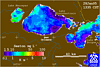 January 28, 1995
 January 31, 1995
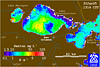 January 30, 1995
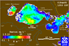 February 1, 1995