 |
| Professional Paper 1643: FIGURE 7 |
Figure 7
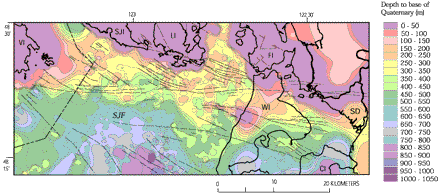
Map showing depth to base of uppermost Pliocene(?) to Pleistocene strata based on outcrops and interpretation of seismic-reflection data, eastern Strait of Juan de Fuca region (see Fig. 2). For offshore data points, we converted two-way travel time to depth by assuming velocities of 1,500 m/s for the water column and 1,800 m/s for Quaternary strata. Dark black lines show coastlines. Thin black lines show structures from Figure 2. CI, Camano Island; FI, Fidalgo Island; LI, Lopez Island; SJF, Strait of Juan de Fuca; SD, Skagit River delta; SJI, San Juan Island; VI, Vancouver Island; WI. Whidbey Island.
Use BACK button to return
Contact: Susan Rhea
This page is brought to you by the Earthquake Hazards Program

