Climate-Vegetation Atlas of North America
This page should be in a new browser window. Move it aside to view the introduction text.
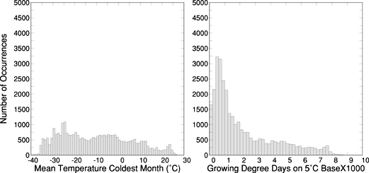 Figure 8. Histograms illustrating distributions of bioclimatic temperature variables (mean temperature of the coldest month (MTCO) and growing degree days (on a 5°C base--GDD5)) among points of the 25-km grid for North America. The height of each column represents the number of grid points that occur within the specified range of the bioclimatic variable on the horizontal axis. |
| AccessibilityFOIAPrivacyPolicies and Notices | |
| |
|