
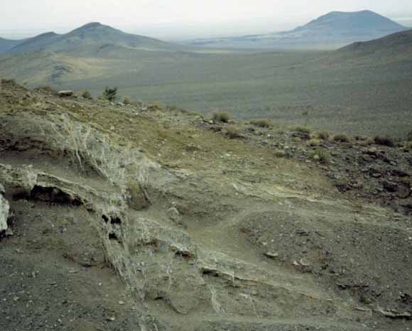
Exposure of the Paintbrush Canyon Fault zone on west side of Busted Butte. South end of Yucca Mountain is visible in middle distance to left, and Lathrop Wells
basaltic cone is on horizon to right. View southward; photograph courtesy of J.A. Coe, U.S. Geological Survey.
|
The U.S. Geological Survey has conducted a comprehensive series of fault studies to determine the history and extent of Quaternary deformation in the Yucca Mountain area of southwestern Nevada as part of a broad, multidisciplinary site-characterization program to evaluate the suitability of the mountain to host a geologic repository for the safe and permanent storage of high-level radioactive wastes. The results of the detailed studies reported here provide basic data that are fundamental to assessing the risks posed by potential future earthquakes and fault displacements with respect to the design and long-term performance of the proposed facilities. The scope and objectives of fault investigations were largely guided by regulations established by the U.S. Nuclear Regulatory Commission and the U.S. Department of Energy for the siting of geologic repositories for the storage of high-level radioactive wastes. This report focuses primarily on eight faults within and near Yucca Mountain that are known to have been active during Quaternary time, as well as on two other conspicuous fault systems in nearby areas that also demonstrate neotectonic activity. The overall objective was to obtain, for each individual fault or fault system, definitive information on the number, magnitude, and estimated dates of surface-rupturing paleoearthquakes. Compiling such information involved extensive field investigations, excavation and logging of trenches, detailed descriptions of surficial deposits and soils, and selected sampling and analyses for numerical age determinations, all of which were performed in accordance with a rigorous set of technical procedures and guidelines that were formulated to comply with quality-assurance standards- an essential requirement for activities related to the siting of nuclear facilities. Beyond the specific purpose of providing a basis for the seismic-risk analysis of Yucca Mountain, the accumulated data and resulting interpretations constitute a valuable contribution to our knowledge and understanding of the neotectonics in this part of the Basin and Range Province. Faults in few other parts of the region have been studied as thoroughly and comprehensively, and so the pattern of Quaternary deformation within this limited area may serve as an example of the structural relations and the locations and magnitudes of potential future earthquakes elsewhere in the Great Basin. |
|
This is the online version of a CD-ROM publication. This publication consists of a book and 26 plates. The book consists of 14 chapter that comprise 212 pages. The plates consist of trench logs. A version of the book is also provided that is accessible to the visually impaired using assistive technology such as screen readers. Download the text of this publication as a 212-page PDF file (pp1689_book.pdf; 8.3 MB) Go to the Plates folder, to see the trench-logs as 26 PDF files (pp1689_plates; 29.8 MB) Go to the files for the visually impaired to access the individual chapters as tagged PDF files (pp1689_book_508; 30.8 MB) Read the Readme file from the CD-ROM version of this publication (1_README.TXT; 56 KB) For questions about the content of this report, contact William Keefer Download a copy of the latest version of Acrobat Reader for free. |
Help |
PDF help |
Publications main page | | Department of the Interior | U.S. Geological Survey | Privacy Statement | Disclaimer | Accessibility | This report is also available on CD-ROM from: USGS Information Services, Box 25286, | Department of the Interior | U.S. Geological Survey | URL of this page: https://pubs.usgs.gov/pp/pp1689 Maintained by: Michael Diggles Created: December 21, 2004 Last modified: January 21, 2005 (mfd) |