

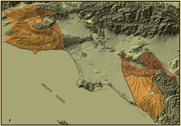
Mapped margins of depositional basins of Sespe-Vaqueros Formations draped on a shaded relief map of the study area.
A preliminary palinspastic reconstruction is presented of the region of the Los Angeles Basin at its 17.4 Ma inception. To create this reconstruction, pertinent paleomagnetic declination data are combined with new maps of the areal extent, thickness variations, and depositional facies of the >17.4 Ma Sespe-Vaqueros Formations and their equivalents. Opening of the Neogene Los Angeles Basin began abruptly about 17.4 Ma. Extensional rifting, with local basaltic volcanism, began the process and accompanied its early stages. Crustal detachment, followed by clockwise tectonic rotation and translation of large crustal blocks has been shown by previous paleomagnetic declination measurements in the western Transverse Ranges Province northwest of the basin and by large strike-slip and dip-slip separations on several major faults transecting it. Successful palinspastic reconstruction of the region to its arrangement before 17.4 Ma depends on understanding and integration of many stratigraphic and structural components. Before 17.4 Ma, fluviatile, alluvial and floodplain deposits, interstratified in the younger part with shallow marine to deeper shelf transgressive equivalents, accumulated to thicknesses as great as several kilometers. This report maps the surface and subsurface extents, thickness variations, and facies patterns of these strata, the Sespe plus Vaqueros and Trancas Formations or equivalents. Separate southeast and northwest sectors are revealed, each with distinctive internal thickness and facies patterns, which must have been related before rifting and transrotation. Terrestrial vertebrate and marine molluscan and foraminiferal fossils, plus magnetostratigraphic profiles of other workers and a few dates of igneous rocks, provide timing for key depositional and structural events. Our preliminary reconstruction of the region brings the internal patterns of the northwest and southeast sectors toward congruity but leaves unsatisfied discrepancies that suggest important information is missing. The reconstruction focuses attention on critical elements, specific uncertainties, and defi- ciencies of prior reconstructions. It also provides a new foundation for further work. |
Download Professional Paper 1690 as a 38-page PDF file (3.5 MB)
For questions about the content of this report, contact Larry Beyer
Download a current version of Acrobat Reader for free
| Help | PDF help | Western reports main page | Western Professional Papers |
| Privacy Statement | Disclaimer | Accessibility |
| Geologic Division | Southern California Areal Mapping Project (SCAMP) |
This report is also available from:
USGS Information Services, Box 25286,
Federal Center, Denver, CO 80225
telephone: 303-202-4210; e-mail: infoservices@usgs.gov