Ground-Water Resources Program; National Research Program
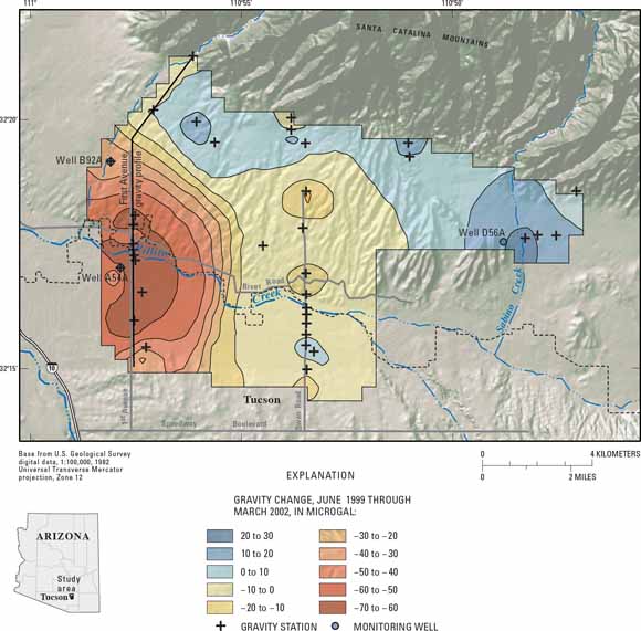
Highly precise measurements of changes in the local gravitational field are useful for detecting amounts of ground-water recharge and withdrawal in arid and semiarid regions. Location of gravity-network stations (pluses), monitoring wells (circles), and changes in gravity (colors), June 1999 through March 2002, near Tucson, Ariz. (from figure 17). Microgravity is one of several geophysical methods discussed in appendix 2.
Abstract
While numerical modeling has revolutionized our understanding of basin-scale hydrologic processes, such models rely almost exclusively on traditional measurements—rainfall, streamflow, and water-table elevations—for calibration and testing. Model calibration provides initial estimates of ground-water recharge. Calibrated models are important yet crude tools for addressing questions about the spatial and temporal distribution of recharge. An inverse approach to recharge estimation is taken of necessity, due to inherent difficulties in making direct measurements of flow across the water table. Difficulties arise because recharging fluxes are typically small, even in humid regions, and because the location of the water table changes with time. Deep water tables in arid and semiarid regions make recharge monitoring especially difficult. Nevertheless, recharge monitoring must advance in order to improve assessments of ground-water recharge. Improved characterization of basin-scale recharge is critical for informed water-resources management.
Difficulties in directly measuring recharge have prompted many efforts to develop indirect methods. The mass-balance approach of estimating recharge as the residual of generally much larger terms has persisted despite the use of increasing complex and finely gridded large-scale hydrologic models. Geophysical data pertaining to recharge rates, timing, and patterns have the potential to substantially improve modeling efforts by providing information on boundary conditions, by constraining model inputs, by testing simplifying assumptions, and by identifying the spatial and temporal resolutions needed to predict recharge to a specified tolerance in space and in time. Moreover, under certain conditions, geophysical measurements can yield direct estimates of recharge rates or changes in water storage, largely eliminating the need for indirect measures of recharge.
This appendix presents an overview of physically based, geophysical methods that are currently available or under development for recharge monitoring. The material is written primarily for hydrogeologists. Uses of geophysical methods for improving recharge monitoring are explored through brief discussions and case studies. The intent is to indicate how geophysical methods can be used effectively in studying recharge processes and quantifying recharge. As such, the material constructs a framework for matching the strengths of individual geophysical methods with the manners in which they can be applied for hydrologic analyses.
The appendix is organized in three sections. First, the key hydrologic parameters necessary to determine the rate, timing, and patterns of recharge are identified. Second, the basic operating principals of the relevant geophysical methods are discussed. Methods are grouped by the physical property that they measure directly. Each measured property is related to one or more of the key hydrologic properties for recharge monitoring. Third, the emerging conceptual framework for applying geophysics to recharge monitoring is presented. Examples of the application of selected geophysical methods to recharge monitoring are presented in nine case studies. These studies illustrate hydrogeophysical applications under a wide range of conditions and measurement scales, which vary from tenths of a meter to hundreds of meters. The case studies include practice-proven as well as emerging applications of geophysical methods to recharge monitoring.
download this report as a 38-page PDF file (pp1703_appendix2.pdf; 18.4 MB).
For questions about the content of this report, contact Ty Ferré
Suggested citation and version history
Back to Ground-Water Recharge in the Arid and Semiarid Southwestern United States
Download a free copy of the current version of Adobe Reader.
| Help
| PDF help
| Western reports main page | Western Professional Papers |
| Water Resources
| National Research Program
| Ground-Water Resources Program |
This report is available only on the Web

![]() U.S. Department of the Interior | U.S. Geological Survey
U.S. Department of the Interior | U.S. Geological Survey
URL: https://pubs.usgs.gov/pp/pp1703/app2/
Page Contact Information: Michael Diggles
Page Last Modified: June 10, 2008