Alaska Science Center
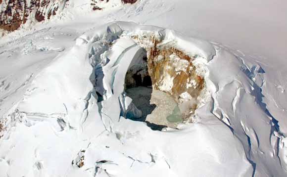
Summit of Mount Spurr, showing fully developed ice cauldron, approximately 200 m across north-south. An area of consistent upwelling and roiling in lake is visible along north shore (to right). View westward. Photograph by Dave Schneider (from figure 10).
Abstract
Mount Spurr, a 3,374-m-high stratovolcano in the Cook Inlet region of Alaska, showed signs of volcanic unrest beginning in 2004 and lasting through 2006. These signs included increases in heat flow, seismicity, and gas flux, which we interpret as the results of a magmatic intrusion in mid-2004. In response, debris-laden meltwater beneath the glacier in Mount Spurr's geothermally active summit basin accumulated as the overlying snow and ice melted. As heat output increased, the icecap subsided into a growing cavity over a meltwater lake, similar to that observed during subglacial volcanic activity in Iceland. An ice plug collapsed into the lake sometime between June 20 and July 8, 2004, forming an ice cauldron that continued to grow in diameter during 2004 and 2005. A freefall of ice and snow into the lake likely caused a mixture of water and debris to be displaced rapidly upward and outward along preexisting englacial and, possibly, subglacial pathways leading away and downslope from the summit basin. Where these pathways intersected crevasses or other weak points in the sloping icefield, the mixture debouched onto the surface, producing dark, fluid debris flows. In summer 2004, the occurrence of two sets of debris flows separated in time by as long as a week suggests two pulses of summit ice collapse, each producing a surge of water and debris from the lake. A single debris flow was also emplaced on May 2, 2005. This event, which was captured by a Web camera, occurred simultaneously with a lake-level drop of ~15 m. To the east of the ice cauldron, a spillway that fed the debris flows has apparently maintained a relatively constant lake level for months at a time. Aerial photographs show that the spillway is in the direction of a breach in the summit crater. Melting of snow and ice at the summit has continued through 2006, with a total meltwater volume of ~5.4 million m3 as of March 2006.
Download this paper as a 33-page PDF file (pp1732b.pdf; 14.3 MB)
For questions about the content of this report, contact Michelle Coombs
Back to Studies by the U.S. Geological Survey in Alaska, 2005
Download a current version of Adobe Reader for free
| Help
| PDF help
| Western reports main page | Western Professional Papers |
| Geologic
Division | Alaska Science Center
|
Alaska Volcano Observatory
|
This report is available only on the Web

![]() U.S. Department of the Interior | U.S. Geological Survey
U.S. Department of the Interior | U.S. Geological Survey
URL: https://pubs.usgs.gov/pp/pp1732/pp1732b/
Page Contact Information: Michael Diggles
Page Last Modified: October 9, 2007
