Studies by the U.S. Geological Survey in Alaska, 2006
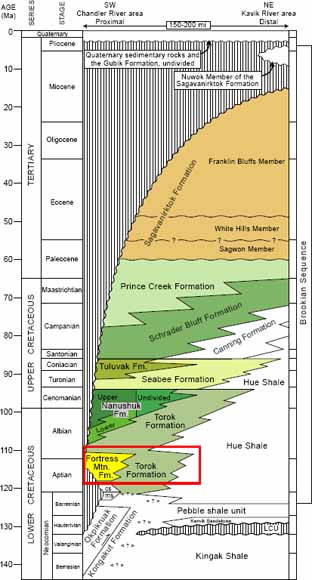
Chronostratigraphic column for the Colville foreland basin, northern Alaska, showing nomenclature and ages of strata of the Brookian sequence. (from Figure 2)
Abstract
An exposure of the Lower Cretaceous Fortress Mountain and Torok Formations along the Siksikpuk River in north-central Alaska provides a rare opportunity to observe the stratigraphic contact between these two formations and to interpret the depositional facies and sequence stratigraphy of the exposed strata. The Fortress Mountain Formation at the base of the measured section includes braided-fluvial and coastal-plain facies deposited in a lowstand-systems tract, and an overlying succession of mostly shallow marine facies deposited in the basal part of a transgressive-systems tract. The overlying Torok Formation includes a thick, upward-deepening succession of marine-shelf to marine-slope facies deposited in the upper part of the transgressive-systems tract. The upper part of the section includes marine-slope and incised-slope-channel turbidite deposits of the Torok Formation, interpreted as a highstand-systems tract.
Consideration of the balance between accommodation and sediment flux inferred from the sequence-stratigraphic analysis suggests that both tectonics and eustasy may have influenced deposition of the lowstand-systems and transgressive-systems tracts. In contrast, the highstand-systems tract may have been primarily influenced by progradation of a regional sediment-dispersal system and by subsidence induced by sediment loading.
Download the text of this report as a 20-page PDF file (pp1739d_text.pdf; 74.6 MB)
Download the plate for this report as a 40" x 36" PDF file: Composite Stratigraphic Section, Gamma-Ray Profile, and Photographs of Parts of the Lower Cretaceous Fortress Mountain and Torok Formations Exposed along the Siksikpuk River, North-Central Alaska (lat 68.531° n., long 152.055° w.) (pp1739d_plate1.pdf; 183 MB)
For questions about the content of this report, contact Dave Houseknecht
Suggested citation and version history
Back to Studies by the U.S. Geological Survey in Alaska, 2006
Download a free copy of the current version of Adobe Reader.
| Help
| PDF help
| Western reports main page | Western Professional Papers |
| Geologic
Division | Alaska Science Center
|
Western Energy Resources
|
This report is available only on the Web

![]() U.S. Department of the Interior | U.S. Geological Survey
U.S. Department of the Interior | U.S. Geological Survey
URL: https://pubs.usgs.gov/pp/pp1739/d/
Page Contact Information: Michael Diggles
Page Last Modified: December 14, 2007