

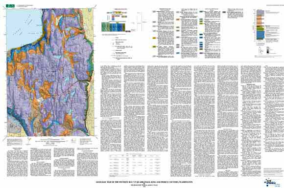
The Poverty Bay quadrangle lies near the center of the Puget Sound region’s intensively developing urban core. Less than 20 km north lies the city of Seattle; downtown Tacoma lies just southwest of the quadrangle. The map area expresses much of the tremendous range of Quaternary environments and deposits found throughout the central Puget Lowland. Much of the ground surface is mantled by a rolling surface of glacial till deposited during the last occupation of the Puget Lowland by a great continental ice sheet about 14,000 years ago. A complex sequence of older unconsolidated sediments extends far below sea level across most of the quadrangle; there are no bedrock exposures at all. |
| File
Name |
File
Type and Description |
File
Size |
| | ||
| FILE for VIEWING and PLOTTING |
||
| PDF file of 52" x 35" map sheet that can be used for viewing map in a browser, as well as for plotting (geologic map, explanatory text, description of map units, and correlation of map units) | 32.9 MB |
|
| README |
||
| ASCII readme file that explains the contents of the two data files | 64 KB |
|
| DATA |
||
| Zipped file that contains geodatabase data objects (including metadata) | 15.1-MB file that opens into a 63.1-MB folder |
|
| Zipped file that contains the shapefile package | 6.3-MB file that opens into an 19.5-MB folder |
|
For questions about the content of this report, contact Derek Booth
| Help
| PDF help
| Publications main page | Western Scientific Investigations Maps | This report is available via print on demand.
| Department of the Interior
| U.S. Geological Survey |
URL of this page: https://pubs.usgs.gov/sim/2004/2854/
Maintained by: Michael Diggles
Date created: December 13, 2004
Date last modified: October 21, 2005 (mfd)