U.S. Geological Survey Scientific Investigations Map 2817-B
Version 1.0 - 2005
Version 1.1 - 2006
Version 1.2 - 2007
1Alaska Division of Oil
and Gas, Anchorage, AK 99501.
2U.S. Geological Survey, Reston, VA 20192.
3Alaska Division of Geological and Geophysical Surveys, Fairbanks,
AK 99709.
 |
This map is a product of the USGS Digital Geologic Maps of Northern Alaska project, which captures in digital format quadrangles across the entire width of northern Alaska. Sources include geologic maps previously published in hardcopy format and recent updates and revisions based on field mapping by the Alaska Department of Natural Resources, Division of Geological and Geophysical Surveys and Division of Oil and Gas, and the U.S. Geological Survey. Individual quadrangles are digitized at either 1:125,000 or 1:250,000 depending on the resolution of source maps. The project objective is to produce a set of digital geologic maps with uniform stratigraphic nomenclature and structural annotation, and publish those maps electronically. The paper version of this map is available for purchase from the USGS Store.
Readme file [23-KB PDF file] SIM 2817–B [11-MB PDF file; 32 x 35 inches] GIS data package [14.2-MB ZIP file; ArcGIS 9.X geodatabase]
|
|
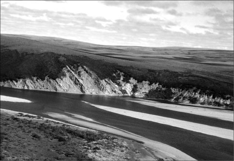
| Upper part of the Nanushuk Formation and lower part of the Seabee Formation exposed near the western end of the Little Twist anticline. View is looking southeastward toward Ninuluk Bluff along the Colville River in Alaska. Contact between Nanushuk and Seabee Formations is exposed at center of photograph. Nanushuk strata are mostly sandstone with interbeds of mudstone and coal. Seabee strata are mostly mudstone with interbeds of sandstone and tuff. Width of exposure is approximately 1,500 feet across the photograph. |

![]() U.S. Department of the Interior |
U.S. Geological Survey
U.S. Department of the Interior |
U.S. Geological Survey
URL: https://pubsdata.usgs.gov/pubs/sim/2005/2817b/index.htm
Page Contact Information: Publishing Services
Page Last Modified: 17:03:31 Thu 01 Dec 2016

