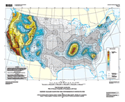
Probabilistic seismic-hazard maps were prepared for the conterminous United States
portraying peak horizontal acceleration and horizontal spectral response
acceleration for 0.2- and 1.0-second periods with probabilities of exceedance
of 10 percent in 50 years and 2 percent in 50 years. All of the maps
were prepared by combining the hazard derived from spatially smoothed
historic seismicity with the hazard from fault-specific sources. The
acceleration values contoured are the random horizontal component. The
reference site condition is firm rock, defined as having an average shear-wave
velocity of 760 m/sec in the top 30 meters corresponding to the boundary
between NEHRP (National Earthquake Hazards Reduction program) site classes
B and C.
This data set represents the results of calculations of hazard curves for a grid of points with a spacing of 0.05 degrees in latitude and longitude. The points were contoured to produce the final representation of the seismic hazard.
Version 1.0
|
| Posted May 2005 |
| Part or all of this report is presented in Portable Document Format. The latest version of Adobe Acrobat Reader or similar software is required to view it. If you wish to download the latest version of Acrobat Reader free of charge, click here.
|
|
