

Side 1 of this 2-sided map |
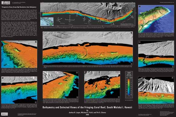
The fringing coral reef along the south side of the island of Moloka‘i is one of the most extensive fringing coral reefs in the Hawaiian chain, if not in the entire Pacific. For a distance of about 40 km, from Hale o Lono on the west to Kamalō on the east, live coral coverage is estimated to be 60 to 90 percent, higher than all but the most shielded reefs in Hawaii. The reef is actively accreting in depths between about 6 and 27 m (20 and 90 ft), creating, as these views show, spurs, grooves, knobs, pits, and pinnacles that are home to thousands of marine organisms. Winter waves restrict active reef accretion beyond the sheltered portion of the coast but the old reef surface in those areas is still populated by numerous individual coral colonies, invertebrates, and fish. These images of the coral reef were created using high-resolution bathymetric data collected in 1999 and 2000 using an airborne laser imaging system called SHOALS (Scanning Hydrographic Operational Airborne Lidar Survey) operated by the U.S. Army Corps of Engineers. The SHOALS system employs laser pulses, or lidar (light detection and ranging) technology to determine water depth at a point roughly every 4 m along the bottom. Over 12 million depth measurements were collected during the Moloka‘i surveys, with a vertical accuracy of 15 cm. The maximum depth lidar can measure is dependent on water clarity. During the Moloka‘i surveys the maximum depth recorded by the lidar system was typically about 35 to 40 m (115 to 130 ft). Detailed map views of the South Moloka‘i reef bathymetry can be found on reverse. For more information on SHOALS, see http://shoals.sam.usace.army.mil/. More information on U.S. Geological Survey studies on coral reefs can be found at http://coralreefs.wr.usgs.gov/. |
Download Scientific Investigations Map 2886 side 1 as a ~44x30-inch PDF file (SIM2886-side1.pdf; 1.8 MB)
Download Scientific Investigations Map 2886 side 2 as a ~29x44-inch PDF file (SIM2886-side2.pdf; 4.6 MB)
For questions about the content of this report, contact Josh Logan
Download a current version of Adobe Reader for free
| Help
| PDF help
| Western reports main page | Western Scientific Investigations Maps |
| Privacy
Statement | Disclaimer
| Accessibility |
| Geologic
Division | Western Region Coastal & Marine Geology
|
This map is available in paper form from:
USGS Information Services, Box 25286,
Federal Center, Denver, CO 80225
telephone: (888) ASK-USGS; e-mail: infoservices@usgs.gov