|
Abstract
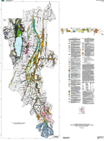
The upper Bear River drainage basin
is located in the Overthrust Belt at the eastern margin
of late Cenozoic basin-and-range faulting. The Bear River
has its headwaters in the Uinta Mountains and flows generally
north through a broad alluvial valley with few, relatively
inactive faults, then jogs abruptly west into Bear Lake
Valley, bounded by active faults. Surficial deposits
in the Bear River Valley above the lake consist mainly
of Pleistocene glacial outwash and Holocene alluvial
deposits; pre-late Pleistocene terrace deposits are mainly
preserved just downstream of glacial deposits in the
Uinta Mountains. Extensive areas of thin pediment deposits
along the valley margins attest to relative stability
of this landscape. Through most of Holocene time, and
at intervals in the Pleistocene, Bear River has flowed
past a groundwater-fed Bear Lake; at other times, most
recently in the late Pleistocene, the lake has risen
and expanded to engulf the river and submerge much of
the valley. Consequently, surficial deposits in Bear
Lake Valley south of the modern river are dominated by
lacustrine and paludal (marsh) deposits of late Pleistocene
and Holocene age; from the river north, Bear River alluvium
is also abundant. Older lake and marsh deposits are locally
preserved along the footwall block of the East Bear Lake
fault zone bounding the east side of the lake. Moraines
of small valley glaciers are preserved along the Bear
River Range northwest of the lake.
|
