
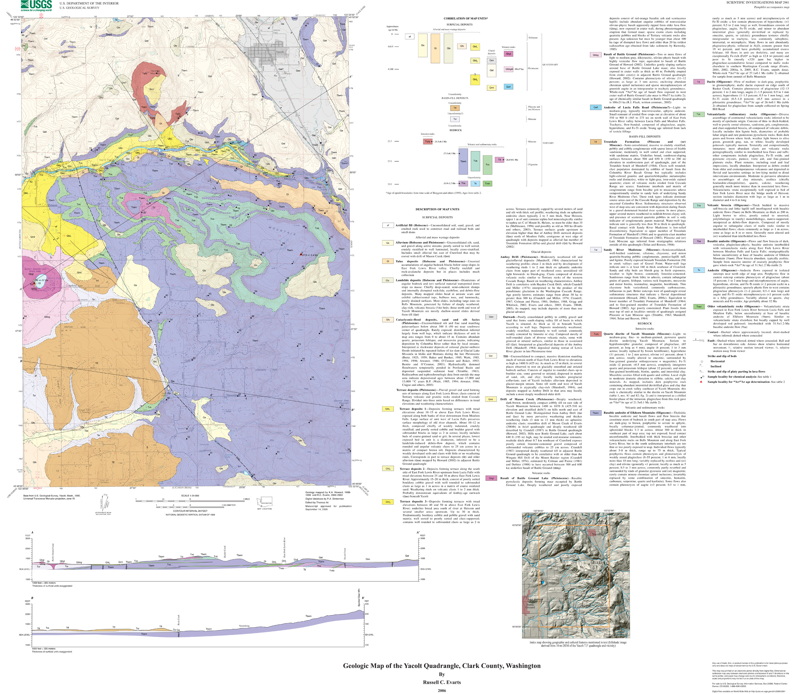
The Yacolt 7.5' quadrangle is situated in the foothills of the western Cascade Range of southwestern Washington approximately 35 km northeast of Portland, Oregon. Since late Eocene time, the Cascade Range has been the locus of an active volcanic arc associated with underthrusting of oceanic lithosphere beneath the North American continent along the Cascadia Subduction Zone. Volcanic and shallow-level intrusive rocks emplaced early in the history of the arc underlie most of the Yacolt quadrangle, forming a dissected and partly glaciated terrain with elevations between 250 and 2180 ft (75 and 665 m). The bedrock surface slopes irregularly but steeply to the southwest, forming the eastern margin of the Portland Basin, and weakly consolidated Miocene and younger basin-fill sediments lap up against the bedrock terrain in the southern part of the map area. A deep canyon, carved by the East Fork Lewis River that flows westward out of the Cascade Range, separates Yacolt and Bells Mountains, the two highest points in the quadrangle. Just west of the quadrangle, the river departs from its narrow bedrock channel and enters a wide alluvial floodplain. Bedrock of the Yacolt quadrangle consists of near-horizontal strata of Oligocene volcanic and volcaniclastic rocks that comprise early products of the Cascade volcanic arc. Basalt and basaltic andesite flows predominate. Most were emplaced on the flanks of a large mafic shield volcano and are interfingered with crudely bedded sections of volcanic breccia of probable lahar origin and a variety of well bedded epiclastic sedimentary rocks. At Yacolt Mountain, the volcanogenic rocks are intruded by a body of Miocene quartz diorite that is compositionally distinct from any volcanic rocks in the map area. The town of Yacolt sits in a north-northwest-trending valley apparently formed within a major fault zone. Several times during the Pleistocene, mountain glaciers moved down the Lewis River valley and spread southward into the map area. The largest glacier(s) covered the entire map area north of the East Fork Lewis River except for the summit of Yacolt Mountain. As the ice receded, it left behind a sculpted bedrock topography thickly mantled by drift, and deposited outwash in the fault-bounded valley at Yacolt and along the East Fork Lewis River valley. This map is a contribution to a program designed to improve geologic knowledge of the Portland Basin region of the Pacific Northwest urban corridor, the densely populated Cascadia forearc region of western Washington and Oregon. More detailed information on the bedrock and surficial geology of the basin and its surrounding area is necessary to refine assessments of seismic risk, ground-failure hazards and resource availability in this rapidly growing region. |
| File
Name |
File
Type and Description |
File
Size |
| | ||
| FILES for VIEWING and PLOTTING |
||
| PDF file of the 32-page Geology pamphlet containing description of map | 1.1 MB |
|
| PDF file of 40" x 36" map sheet that can be used for viewing map in a browser, as well as for plotting (geologic map, description of map units, and correlation of map units) | 12.2 MB |
|
| JPG file of 10" x 8" 300 dpi version of the map sheet that can be used for viewing map in a browser or printing on letter-sized paper | 1.9 MB |
|
| README |
||
| PDF readme file that explains the contents of the two data files | 112 KB |
|
| DATA |
||
| Metadata | 88 KB |
|
| Zipped file that contains geodatabase data objects | 17.5-MB file that opens into a 53.7-MB folder |
|
| Zipped file that contains the shapefile package | 1.4-MB file that opens into an 2.2-MB folder |
|
For questions about the content of this report, contact Russ Evarts
Version history| Help
| PDF help
| Publications main page | Western Scientific Investigations Maps | This report is available via print on demand.
| Department of the Interior
| U.S. Geological Survey |
URL of this page: https://pubs.usgs.gov/sim/2006/2901/
Maintained by: Michael Diggles
Date created: June 19, 2006
Date last modified: June 20, 2006 (mfd)