Scientific Investigations Map 2921
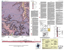 
This map summarizes the geology of the Western Grove 7.5-minute quadrangle in northern Arkansas that is located on the southern flank of the Ozark dome, a late Paleozoic regional uplift. The exposed bedrock of this map area comprises approximately 1,000 ft of Ordovician and Mississippian carbonate and clastic sedimentary rocks that have been mildly folded and broken by faults. A segment of the Buffalo River loops through the southern part of the quadrangle, and the river and adjacent lands form part of Buffalo National River, a park administered by the U.S. National Park Service. This geologic map provides information to better understand the natural resources of the Buffalo River watershed, particularly its karst hydrogeologic framework. |
Version 1.0 Posted May 2006
|
Part or all of this report is presented in Portable Document Format (PDF); the latest version of Adobe Acrobat Reader or similar software is required to view it. Download the latest version of Acrobat Reader, free of charge or go to access.adobe.com for free tools that allow visually impaired users to read PDF files.
