Scientific Investigations Map 2952
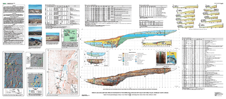 
From the Introduction This report contains field and laboratory data from a study of the Steens fault zone near Denio, Nev. The 200-km-long Steens fault zone forms the longest, most topographically prominent fault-bounded escarpment in the Basin and Range of southern Oregon and northern Nevada. The down-to-the-east normal fault is marked by Holocene fault scarps along nearly half its length, including the southern one-third of the fault from the vicinity of Pueblo Mountain in southern Oregon to the southern margin of Bog Hot Valley (BHV) southwest of Denio, Nev. We studied this section of the fault to better constrain late Quaternary slip rates, which we hope to compare to deformation rates derived from a recently established geodetic network in the region (Hammond and Thatcher, 2005). We excavated a trench in May 2003 across one of a series of right-stepping fault scarps that extend south from the southern end of the Pueblo Mountains and traverse the floor of Bog Hot Valley, about 4 km south of Nevada State Highway 140. This site was chosen because of the presence of well-preserved fault scarps, their development on lacustrine deposits thought to be suitable for luminescence dating, and the proximity of two geodetic stations that straddle the fault zone. We excavated a second trench in the southern BHV, but the fault zone in this trench collapsed during excavation and thus no information about fault history was documented from this site. We also excavated a soil pit on a lacustrine barrier bar in the southern Pueblo Valley (PV) to better constrain the age of lacustrine deposits exposed in the trench. The purpose of this report is to present photomosaics and trench logs, scarp profiles and slip data, soils data, luminescence and radiocarbon ages, and unit descriptions obtained during this investigation. We do not attempt to use the data presented herein to construct a paleoseismic history of this part of the Steens fault zone; that history will be the subject of a future report. This map is available from USGS: Maps on Demand. |
Version 1.0 Posted November 2006
|
Part or all of this report is presented in Portable Document Format (PDF); the latest version of Adobe Acrobat Reader or similar software is required to view it. Download the latest version of Acrobat Reader, free of charge or go to access.adobe.com for free tools that allow visually impaired users to read PDF files.
