Skip Links

Scientific Investigations Map 2955

About USGS /  Science Topics /  Maps, Products & Publications /  Education / Publication: FAQ

Data Related to Late Quaternary Surface Faulting on the Sangre de Cristo Fault, Rito Seco Site, Costilla County, Colorado

By Anthony J. Crone, Michael N. Machette, Lee-Ann Bradley, and Shannon A. Mahan

Link to Report PDF (15 MB)Download Publication
Large File Warning!
SIM 2955 PDF (15 MB)
Right-Click to 'Save As' or 'Download'

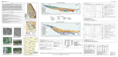
In this report, we present detailed maps of the trenches and a compilation of field and laboratory data used to support our interpretation of the history of four (PE1–PE4) prehistoric surface-faulting earthquakes at this site.

This map is available from USGS: Maps on Demand.

Version 1.0

Posted January 2007

  • Map PDF (15 MB)
    (This text-only version of the report meets accessibility standards defined by Section 508.)
  • *Downloading Suggestion
    It is best to download this file to your hard drive rather than open it inside your browser. A standard click may automatically open the file inside the browser but doing so will result in a very slow load. Downloading the file may take several moments but will be worth the wait. Once it is downloaded, open it from your hard drive—it will open in a fraction of the time it would take to open over the Internet.

Part or all of this report is presented in Portable Document Format (PDF); the latest version of Adobe Acrobat Reader or similar software is required to view it. Download the latest version of Acrobat Reader, free of charge or go to access.adobe.com for free tools that allow visually impaired users to read PDF files.

USA.gov logo