Western Earth Surface Processes
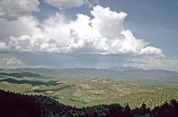
View from Badger Mountain area looking north to Hancock Summit. Tertiary volcanic rocks unconformably overlie Cambrian and Ordovician rocks in the foreground.
The Pahranagat Range 30’ x 60’ quadrangle lies within an arid, sparsely populated part of Lincoln and Nye Counties, southeastern Nevada. Much of the area is public land that includes the Desert National Wildlife Range, the Pahranagat National Wildlife Refuge, and the Nellis Air Force Base. The topography, typical of much of the Basin and Range Province, consists of north-south-trending ranges and intervening broad alluvial valleys. Elevations range from about 1,000 to 2,900 m. At the regional scale, the Pahranagat Range quadrangle lies within the Mesozoic and early Tertiary Sevier Fold-and-Thrust Belt and the Cenozoic Basin and Range Province. The quadrangle is underlain by a Proterozoic to Permian miogeoclinal section, a nonmarine clastic and volcanic section of middle Oligocene or older to late Miocene age, and alluvial deposits of late Cenozoic age. The structural features that are exposed reflect relatively shallow crustal deformation. Mesozoic deformation is dominated by thrust faults and asymmetric or open folds. Cenozoic deformation is dominated by faults that dip more than 45¡ and dominostyle tilted blocks. At least three major tectonic events have affected the area: Mesozoic (Sevier) folding and thrust faulting, pre-middle Oligocene extensional deformation, and late Cenozoic (mainly late Miocene to Holocene) extensional deformation. Continued tectonic activity is expressed in the Pahranagat Range area by seismicity and faults having scarps that cut alluvial deposits.
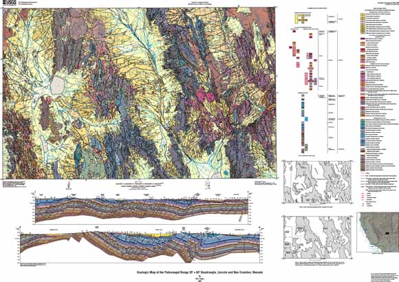
Download the map as a 53" x 38" PDF file (sim2904_map.pdf; 16.6 MB).
Download the accompanying pamphlet as a 15-page PDF file (sim2904_pamphlet.pdf; 208 kB).
For questions about the content of this report, contact Angela Jayko
Suggested citation and version history
Download a free copy of the current version of Adobe Reader.
| Help
| PDF help
| Western reports main page | Western Scientific Investigations Maps |
| Geologic
Division | Western Earth Surface Processes
|

![]() U.S. Department of the Interior | U.S. Geological Survey
U.S. Department of the Interior | U.S. Geological Survey
URL: https://pubs.usgs.gov/sim/2007/2904/
Page Contact Information: Michael Diggles
Page Last Modified: November 15, 2007