Scientific Investigations Map 2966
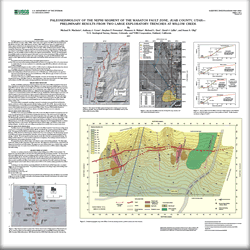 
In 2004, we identified a small parcel of U.S. Forest Service land at the mouth of Willow Creek (about 5 km west of Mona, Utah) that was suitable for trenching. At the Willow Creek site, which is near the middle of the southern strand of the Nephi segment, the WFZ has vertically displaced alluvial-fan deposits >6–7 m, forming large, steep, multiple-event scarps. In May 2005, we dug two 4- to 5-m-deep backhoe trenches at the Willow Creek site, identified three colluvial wedges in each trench, and collected samples of charcoal and A-horizon organic material for AMS (acceleration mass spectrometry) radiocarbon dating, and sampled fine-grained eolian and colluvial sediment for luminescence dating. The trenches yielded a stratigraphic assemblage composed of moderately coarse-grained fluvial and debris-flow deposits and discrete colluvial wedges associated with three faulting events (P1, P2, and P3). About one-half of the net vertical displacement is accommodated by monoclinal tilting of fan deposits on the hanging-wall block, possibly related to massive ductile landslide deposits that are present beneath the Willow Creek fan. The timing of the three surface-faulting events is bracketed by radiocarbon dates and results in a much different fault chronology and higher slip rates than previously considered for this segment of the Wasatch fault zone.
1U.S. Geological Survey, Denver, Colorado, and 2URS Corporation, Oakland, California |
Version 1.0 Posted May 2007
|
Machette, M.N., Crone, A.J. Personius, S.F., Mahan, S.A., Dart, R.L., Lidke, D.J., and Olig, S.S., 2007, Paleoseismology of the Nephi segment of the Wasatch fault zone, Juab County, Utah—Preliminary results from two large exploratory trenches at Willow Creek: U.S. Geological Survey Scientific Investigations Map 2966, 2 sheets.

![]() U.S. Department of the Interior | U.S. Geological Survey
U.S. Department of the Interior | U.S. Geological Survey
URL: http://pubsdata.usgs.gov/pubs/sim/2007/2966/index.html
Questions or Assistance: Contact USGS
Last modified: Thursday, 01-Dec-2016 17:08:28 EST
