U.S. Geological Survey Scientific Investigations Map 2927
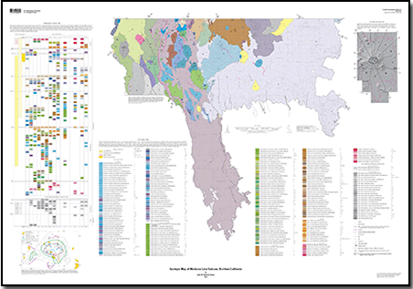
IntroductionMedicine Lake volcano forms a broad, seemingly nondescript highland, as viewed from any angle on the ground. Seen from an airplane, however, treeless lava flows are scattered across the surface of this potentially active volcanic edifice. Lavas of Medicine Lake volcano, which range in composition from basalt through rhyolite, cover more than 2,000 km2 east of the main axis of the Cascade Range in northern California. Across the Cascade Range axis to the west-southwest is Mount Shasta, its towering volcanic neighbor, whose stratocone shape contrasts with the broad shield shape of Medicine Lake volcano. Hidden in the center of Medicine Lake volcano is a 7 km by 12 km summit caldera in which nestles its namesake, Medicine Lake. The flanks of Medicine Lake volcano, which are dotted with cinder cones, slope gently upward to the caldera rim, which reaches an elevation of nearly 8,000 ft (2,440 m). The maximum extent of lavas from this half-million-year-old volcano is about 80 km north-south by 45 km east-west. In postglacial time, 17 eruptions have added approximately 7.5 km3 to its total estimated volume of 600 km3, and it is considered to be the largest by volume among volcanoes of the Cascades arc. The volcano has erupted nine times in the past 5,200 years, a rate more frequent than has been documented at all other Cascades arc volcanoes except Mount St. Helens. 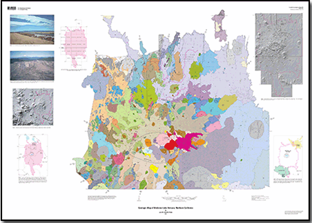
|
Last modified August 25, 2011
Files for Viewing and Plotting
Data to accompany Scientific Investigations Map 2927By David W. Ramsey, Tracey J. Felger, Ellen Lougee, Peggy E. Bruggman, and Julie M. Donnelly-Nolan
These pages contain the spatial database used to produce the geologic map and additional photographs. The main component of this site is a geologic map database prepared using ArcInfo GIS. Also included are links to chemical analyses for more than 600 pre-Holocene rocks collected at or near Medicine Lake volcano from U.S. Geological Survey Open-File Report 2008-1094.
Contact Information
Volcano Science Center - Menlo Park U.S. Geological Survey 345 Middlefield Road, MS 910 Menlo Park, CA 94025 http://volcanoes.usgs.gov/ Part of this report is presented in Portable Document Format (PDF); the latest version of Adobe Reader or similar software is required to view it. Download the latest version of Adobe Reader, free of charge. |
Donnelly-Nolan, J.M., 2010, Geologic map of Medicine Lake volcano, northern California: U.S. Geological Survey Scientific Investigations Map 2927, pamphlet 48 p., 2 sheets, scale 1:50,000, https://pubs.usgs.gov/sim/2927/.
Introduction
Previous Geologic Work
Geologic and Tectonic Setting
Pre-MLV Volcanic Activity
Eruptive History of MLV
The Caldera
Glacial History
Hazards, Resources, and Recreation
Acknowledgments
Introduction to Description of Map Units
Description of Map Units
References Cited
Sheet 1
Sheet 2

![]() U.S. Department of the Interior |
U.S. Geological Survey
U.S. Department of the Interior |
U.S. Geological Survey
URL: https://pubsdata.usgs.gov/pubs/sim/2927/
Page Contact Information: USGS Publications Team
Page Last Modified: Friday, 07-Apr-2017 16:52:43 EDT
