
|
|
Scientific Investigations Map 2940 |
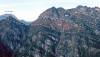
| TKso-1. The Southern Picket Range [MBne] is eroded from orthogneiss of the Skagit Gneiss Complex (TKso). View south across McMillan Creek from south ridge of Luna Peak. Photographed in 1966. View image without annotation |

|
Other photos that show unit TKso:
  |