Scientific Investigations Map 2983
Introduction
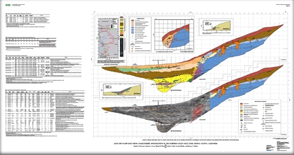
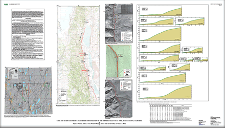
This report contains field and laboratory data from a paleoseismic study of the Surprise Valley fault zone near Cedarville, California. The 85-km-long Surprise Valley fault zone forms the western active margin of the Basin and Range province in northeastern California. The down-to-the-east normal fault is marked by Holocene fault scarps along most of its length, from Fort Bidwell on the north to near the southern end of Surprise Valley. We studied the central section of the fault to determine ages of paleoearthquakes and to better constrain late Quaternary slip rates, which we hope to compare to deformation rates derived from a recently established geodetic network in the region (Hammond and Thatcher, 2005; 2007). We excavated a trench in June 2005 across a prominent fault scarp on pluvial Lake Surprise deltaic sediments near the mouth of Cooks Canyon, 4 km north of Cedarville. This site was chosen because of the presence of a well-preserved fault scarp and its development on lacustrine deposits thought to be suitable for luminescence dating. We also logged a natural exposure of the fault in similar deltaic sediments near the mouth of Steamboat Canyon, 11 km south of Cedarville, to better understand the along-strike extent of surface ruptures. The purpose of this report is to present photomosaics, trench, drill hole, and stream exposure logs; scarp profiles; and fault slip, tephrochronologic, radiocarbon, luminescence, and unit description data obtained during this investigation. We do not attempt to use the data presented herein to construct a paleoseismic history of this part of the Surprise Valley fault zone; that history will be the subject of a future report. |
Posted August 2008 |
Personius, S.F., Crone, A.J., Machette, M.N., Lidke, D.J., Bradley, L.-A., and Mahan, S.A., 2007, Logs and scarp data from a paleoseismic investigation of the Surprise Valley fault zone, Modoc County, California: U.S. Geological Survey Scientific Investigations Map 2983, 2 sheets.

![]() U.S. Department of the Interior | U.S. Geological Survey
U.S. Department of the Interior | U.S. Geological Survey
URL: http://pubsdata.usgs.gov/pubs/sim/2983/index.html
Questions or Assistance: Contact USGS
Last modified: Thursday, 01-Dec-2016 17:11:08 EST
