Scientific Investigations Map 2986
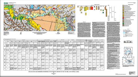 
The Tok area 1:100,000-scale map, through which the Alaska Highway runs, is in east-central Alaska about 160 km west of the Yukon border. The surficial geologic mapping in the map area is in support of the "Geologic Mapping in support of land, resources, and hazards issues in Alaska" Project of the USGS National Cooperative Geologic Mapping Program. The Tok map area contains parts of three physiographic provinces, the Alaska Range, the Yukon-Tanana Upland, and the Northway-Tanana Lowland. The high, rugged, glaciated landscape of the eastern Alaska Range dominates the southwestern map area. The highest peak, an unnamed summit at the head of Cathedral Rapids Creek No. 2, rises to 2166 m. The gently rolling hills of the Yukon-Tanana Upland, in the northern map area, rise to about 1000 m. The Northway-Tanana Lowland contains the valley of the westerly flowing Tanana River. Elevations along the floor of the lowland generally range between 470 and 520 m. The dominant feature within the map is the Tok fan, which occupies about 20 percent of the map area. This large (450 km2), nearly featureless fan contains a high percentage of volcanic clasts derived from outside the present-day drainage of the Tok River. Because the map area is dominated by various surficial deposits, the map depicts 26 different surficial units consisting of man-made, alluvial, colluvial, eolian, lacustrine, organic, glaciofluvial, glacial, and periglacial deposits. The accompanying table provides information concerning the various units including their properties, characteristics, resource potential, and associated hazards in this area of the upper Tanana valley. |
Version 1.0 Posted December 2007
|
Carrara, P.E., 2007, Geologic map and engineering properties of the surficial deposits of the Tok area, east-central Alaska: U.S. Geological Survey Scientific Investigations Map 2986, scale 1:100,000.

![]() U.S. Department of the Interior | U.S. Geological Survey
U.S. Department of the Interior | U.S. Geological Survey
URL: http://pubsdata.usgs.gov/pubs/sim/2986/index.html
Questions or Assistance: Contact USGS
Last modified: Thursday, 01-Dec-2016 17:10:15 EST
