Scientific Investigations Map 2990
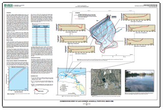
AbstractLago Guerrero is located in Aguadilla, northwestern Puerto Rico (fig. 1). The reservoir has a surface area of about 32,000 square meters and is excavated in Aymamón Limestone of Miocene age. This bedrock consists of chalk interbed-ded with solution-riddled hard limestone (Monroe, 1969). The reservoir was constructed in the 1930s as part of the Isabela Hydroelectric System to regulate flows to two hydroelectric plants–Central Isabel No. 2, at an elevation of about 110 meters above mean sea level, and Central Isabel No. 3, at about 55 meters above mean sea level. Hydroelectric power generation was discontinued during the early 1960s, although the exact date is unknown (Puerto Rico Electric Power Authority, written commun., 2007). The principal use of the reservoir since then has been to regulate flow to two public-supply water filtration plants and supply irrigation water for the Aguadilla area. Flow into the reservoir is derived from Lago Guajataca through a 26-kilometer-long Canal Principal de Diversion concrete canal (Puerto Rico Electric Power Authority, written commun., 2001). Additional inflow occurs on an incidental basis only during intensive rainfall from the immediate drainage area. The present Lago Guerrero drainage area is undetermined, due to the irregular and complex topography of the limestone terrain and anthropogenic modifications to the stormwater drainage system. Stormwater runoff, however, is presumed to be negligible compared to the almost constant inflow to the reservoir of about 59,300 cubic meters per day from Lago Guajataca (CSA Group, 2000). On March 9, 2006, the U.S. Geological Survey (USGS), Caribbean Water Science Center, in cooperation with the Puerto Rico Electric Power Authority (PREPA), conducted a bathymetric survey of Lago Guerrero to determine the storage capacity of the reservoir and sedimentation amount since a previous survey conducted on May 30, 2001. The March 2006 survey was made to develop a bathymetric map of the reservoir, establish baseline data for future reservoir capacity comparisons, and to estimate the average sedimentation rate over the preceding 5 years. |
Please visit http://pr.water.usgs.gov/ for more information about USGS activities in the Caribbean (Puerto Rico and the U.S. Virgin Islands). Part or all of this report is presented in Portable Document Format (PDF); the latest version of Adobe Reader or similar software is required to view it. Download the latest version of Adobe Reader, free of charge. |
Soler-López, L.R., 2007, Sedimentation survey of LagoGuerrero, Aguadilla, Puerto Rico, March 2006: U.S. Geological Survey Scientific Investigations Map 2007-2990, 1 sheet. Online only.

![]() U.S. Department of the Interior |
U.S. Geological Survey
U.S. Department of the Interior |
U.S. Geological Survey
URL: https://pubsdata.usgs.gov/pubs/sim/2990/
Page Contact Information: Contact USGS
Page Last Modified: Thursday, 01-Dec-2016 17:14:27 EST
