Scientific Investigations Map 2993
IntroductionThe Pine Ridge Indian Reservation and Bennett County are located in southwest South Dakota. The Pine Ridge Indian Reservation includes all of Shannon County and the part of Jackson County south of the White River. Extensive Indian trust lands are in Bennett County. For purposes of this map, the Pine Ridge Indian Reservation and all of Bennett County are included in the study area (sheet 1). Ground water from wells and springs is the predominant source of public and domestic supply within the study area. The Arikaree aquifer is the largest source of ground water throughout this area. The Oglala Sioux Tribe is developing a ground-water management plan designed to “preserve, protect and maintain the quality of ground water for living and future members and non-members of the Oglala Sioux Indian Tribe within the internal and external boundaries of the Pine Ridge Reservation” (Michael Catches Enemy, Oglala Sioux Tribe Natural Resources Regulatory Agency, oral commun., 2007). Hydrologic information about the Arikaree aquifer is important to managing this resource. In 1998, the U.S. Geological Survey (USGS) began working in cooperation with the Oglala Sioux Tribe to develop a potentiometric map of the Arikaree aquifer in Jackson and Shannon Counties, with a primary component of that effort being a well inventory in those counties. In 2003, the study area was expanded to include Bennett County. 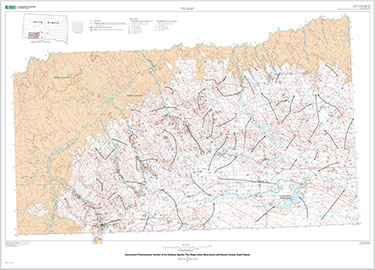  |
Version 1.0 March 2008
| |
Carter, J.M., and Heakin, A.J., 2007, Potentiometric surface of the Arikaree aquifer, Pine Ridge Indian Reservation and Bennett County, South Dakota: U.S. Geological Survey Scientific Investigations Map 2993, 2 sheets.
| Send questions or comments about this report to GS-W-SD_webmaster. For more information about USGS activities in South Dakota, visit the USGS South Dakota Water Science Center home page. |
Document Accessibility: Part or all of this report is presented in Portable Document Format (PDF); the latest version of Adobe Acrobat Reader or similar software is required to view it. Download the latest version of Acrobat Reader, free of charge or go to access.adobe.com for free tools that allow visually impaired users to read PDF files. |

![]() U.S. Department of the Interior | U.S. Geological Survey
U.S. Department of the Interior | U.S. Geological Survey
URL: http://pubsdata.usgs.gov/pubs/sim/2993/index.html
Questions or Assistance: Contact USGS
Last modified: Thursday, 01-Dec-2016 17:10:12 EST
