Astrogeology Research Program
The Magellan spacecraft orbited Venus from August 10, 1990, until it plunged into the Venusian atmosphere on October 12, 1994. Magellan Mission objectives included (1) improving the knowledge of the geological processes, surface properties, and geologic history of Venus by analysis of surface radar characteristics, topography, and morphology and (2) improving the knowledge of the geophysics of Venus by analysis of Venusian gravity.
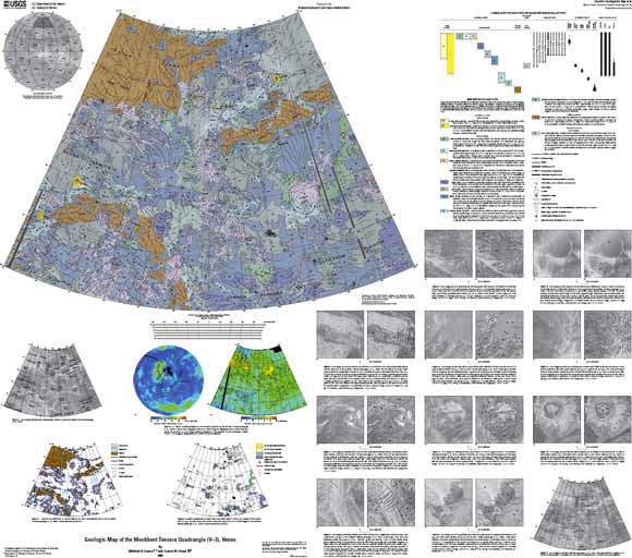
The Meskhent Tessera quadrangle is in the northern hemisphere of Venus and extends from lat 50° to 75° N. and from long 60° to 120° E. In regional context, the Meskhent Tessera quadrangle is surrounded by extensive tessera regions to the west (Fortuna and Laima Tesserae) and to the south (Tellus Tessera) and by a large basinlike lowland (Atalanta Planitia) on the east. The northern third of the quadrangle covers the easternmost portion of the large topographic province of Ishtar Terra (northwestern map area) and the more localized upland of Tethus Regio (northeastern map area).
Download this map as an ~47" x 42" PDF document (sim3018_map.pdf; 45.6 MB)
Download the accompanying pamphlet as an 18-page PDF document (sim3018_pamphlet.pdf; 800 kB)
For questions about the content of this report, contact Ken Tanaka
Suggested citation and version history
Download a free copy of the current version of Adobe Reader.
| Help
| PDF help
| Publications main page | Other Planetary Maps |
| Geologic
Division | Astrogeology Research Program
|
This map is available in paper form from:
USGS Information Services, Box 25286,
Federal Center, Denver, CO 80225
telephone: (888) ASK-USGS; e-mail: infoservices@usgs.gov

![]() U.S. Department of the Interior | U.S. Geological Survey
U.S. Department of the Interior | U.S. Geological Survey
URL: https://pubs.usgs.gov/sim/3018/
Page Contact Information: Michael Diggles
Page Created: August 29, 2008
Page Last Modified: November 10, 2008