Scientific Investigations Map 3061
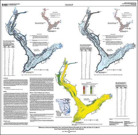
SummaryOn December 14, 2005, the embankment of the upper reservoir at the Taum Sauk pump storage facility, Reynolds County, Missouri, catastrophically failed and flooded the East Fork Black River, depositing debris and sediment in Johnson’s Shut-Ins State Park, the lower Taum Sauk Reservoir, and downstream in the Black River (location map). A bathymetric survey conducted December 20–22, 2005, documented the bathymetry of the lower Taum Sauk Reservoir after the upper reservoir failure (Rydlund, 2006). After subsequent excavation of sediment and debris from the lower reservoir by Ameren Union Electric (UE), the U.S. Geological Survey (USGS), in collaboration with Roux Associates Inc., conducted a bathymetric survey of the lower Taum Sauk Reservoir on June 16–19, 2008, to prepare a current (2008) bathymetric map (fig. 1) for the lower reservoir, establish a current (2008) elevation-area and capacity table, and determine reservoir area and capacity differences between the 2005 and 2008 bathymetric surveys. |
Version 1.0 Posted December 2008 For additional information contact: Part or all of this report is presented in Portable Document Format (PDF); the latest version of Adobe Reader or similar software is required to view it. Download the latest version of Adobe Reader, free of charge. |
Wilson, G.L., and Richards, J.M., 2008, Differences in reservoir bathymetry, area, and capacity between December 20–22, 2005, and June 16–19, 2008, for lower Taum Sauk Reservoir, Reynolds County, Missouri: U.S. Geological Survey Scientific Investigations Map 3061, 1 sheet.

![]() U.S. Department of the Interior | U.S. Geological Survey
U.S. Department of the Interior | U.S. Geological Survey
URL: http://pubsdata.usgs.gov/pubs/sim/3061/index.html
Questions or Assistance: Contact USGS
Last modified: Thursday, 01-Dec-2016 17:12:50 EST
