Scientific Investigations Map 3086
1Ecology Department, NatureServe, Boulder, Colo.
2Parallel Inc., Lakewood, Colo.
Abstract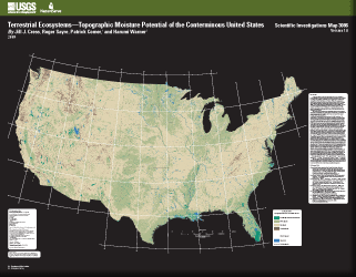
As part of an effort to map terrestrial ecosystems, the U.S. Geological Survey has generated topographic moisture potential classes to be used in creating maps depicting standardized, terrestrial ecosystem models for the conterminous United States, using an ecosystems classification developed by NatureServe. A biophysical stratification approach, developed for South America and now being implemented globally, was used to model the ecosystem distributions. Substrate moisture regimes strongly influence the differentiation and distribution of terrestrial ecosystems, and therefore topographic moisture potential is one of the key input layers in this biophysical stratification. The method used to produce these topographic moisture potential classes was based on the derivation of ground moisture potential using a combination of computed topographic characteristics (CTI, slope, and aspect) and mapped National Wetland Inventory (NWI) boundaries. This method does not use climate or soil attributes to calculate relative topographic moisture potential since these characteristics are incorporated into the ecosystem model though other input layers. All of the topographic data used for this assessment were derived from the USGS 30-meter National Elevation Dataset (NED ) including the National Compound Topographic Index (CTI). The CTI index is a topographically derived measure of slope for a raster cell and the contributing area from upstream raster cells, and thus expresses potential for water flow to a point. In other words CTI data are “a quantification of the position of a site in the local landscape,” where the lowest values indicate ridges and the highest values indicate stream channels, lakes and ponds. These CTI values were compared to independent estimates of water accumulation by obtaining geospatial data from a number of sample locations representing two types of NWI boundaries: freshwater emergent wetlands and freshwater forested/shrub wetlands. Where these shorelines (the interface between the NWI wetlands and adjacent land) occurred, the CTI values were extracted and a histogram of their statistical distributions was calculated. Based on an evaluation of these histograms, CTI thresholds were developed to separate periodically saturated or flooded land, mesic uplands (moderately moist), and uplands. After the range of CTI values for these three different substrate moisture regimes was determined, the CTI values were grouped into three initial topographic moisture potential classes. As a final step in the generation of this national data layer, the uplands classification was subdivided into either very dry uplands or dry uplands. Very dry uplands were defined as uplands with relatively steep, south-facing slopes, and identification of this class was based on the slope and aspect datasets derived from the NED. The remaining uplands that did not meet these additional criteria were simply re-classified as dry uplands. The final National Topographic Moisture Potential dataset for the conterminous United States contains four classes: periodically saturated or flooded land (CTI ≥ 18.5), mesic uplands (12 ≤ CTI < 18.5), dry uplands (CTI < 12), and very dry uplands (CTI < 12, Slope > 24 degrees and 91 degrees ≤ Aspect ≤ 314 degrees). This map shows a smoothed and generalized image of the four topographic moisture potential classes. Additional information about this map and any of the data developed for the ecosystems modeling of the conterminous United States is available online at http://rmgsc.cr.usgs.gov/ecosystems/. |
First posted August 4, 2009 For additional information contact:
Part or all of this report is presented in Portable Document Format (PDF); the latest version of Adobe Reader or similar software is required to view it. Download the latest version of Adobe Reader, free of charge. |
Cress, J.J., Sayre, Roger, Comer, Patrick, and Warner, Harumi, 2009, Terrestrial Ecosystems—Topographic moisture potential of the conterminous United States: U.S. Geological Survey Scientific Investigations Map 3086, scale 1:5,000,000, 1 sheet.

![]() U.S. Department of the Interior |
U.S. Geological Survey
U.S. Department of the Interior |
U.S. Geological Survey
URL: http://pubsdata.usgs.gov/pubs/sim/3086/index.html
Page Contact Information: GS Pubs Web Contact
Page Last Modified: Thursday, 01-Dec-2016 17:15:32 EST
