Scientific Investigations Map 3090
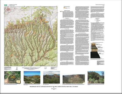
This report presents a preliminary map of landslide deposits in the Mesa Verde National Park area (see map sheet) at a compilation scale of 1:50,000. Landslide is a general term for landforms produced by a wide variety of gravity-driven mass movements, including various types of flows, slides, topples and falls, and combinations thereof produced by the slow to rapid downslope transport of surficial materials or bedrock. The map depicts more than 200 landslides ranging in size from small (0.01 square miles) earthflows and rock slumps to large (greater than 0.50 square miles) translational slides and complex landslides (Varnes, 1978). This map has been prepared to provide a regional overview of the distribution of landslide deposits in the Mesa Verde area, and as such constitutes an inventory of landslides in the area. The map is suitable for regional planning to identify broad areas where landslide deposits and processes are concentrated. It should not be used as a substitute for detailed site investigations. Specific areas thought to be subject to landslide hazards should be carefully studied before development. Many of the landslides depicted on this map are probably stable as they date to the Pleistocene (approximately 1.8–0.011 Ma) and hence formed under a different climate regime. However, the recognition of these landslides is important because natural and human-induced factors can alter stability. Reduction of lateral support (by excavations or roadcuts), removal of vegetation (by fire or development), or an increase in pore pressure (by heavy rains) may result in the reactivation of landslides or parts of landslides. |
First posted October 8, 2009 For additional information contact: Part or all of this report is presented in Portable Document Format (PDF); the latest version of Adobe Reader or similar software is required to view it. Download the latest version of Adobe Reader, free of charge. |
Carrara, P.E., 2009, Preliminary map of landslide deposits in the Mesa Verde National Park area, Colorado: U.S. Geological Survey Scientific Investigations Map 3090, scale 1:50,000.

![]() U.S. Department of the Interior |
U.S. Geological Survey
U.S. Department of the Interior |
U.S. Geological Survey
URL: http://pubsdata.usgs.gov/pubs/sim/3090/index.html
Page Contact Information: GS Pubs Web Contact
Page Last Modified: Thursday, 01-Dec-2016 17:17:20 EST
