Scientific Investigations Map 3091
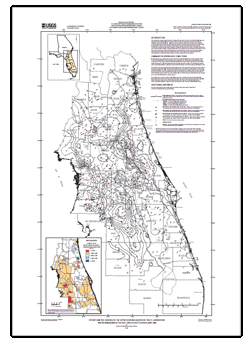
IntroductionThis map depicts the potentiometric surface of the Upper Floridan aquifer in the St. Johns River Water Management District and vicinity for May 2009. Potentiometric contours are based on water-level measurements collected at 625 wells during the period May 14 – May 29, near the end of the dry season. Some contours are inferred from previous potentiometric-surface maps with larger well networks. The potentiometric surface of the carbonate Upper Floridan aquifer responds mainly to rainfall, and more locally, to groundwater withdrawals and spring flow. Potentiometric-surface highs generally correspond to topographic highs where the aquifer is recharged. Springs and areas of diffuse upward leakage naturally discharge water from the aquifer and are most prevalent along the St. Johns River. Areas of discharge are reflected by depressions in the potentiometric surface. Groundwater withdrawals locally have lowered the potentiometric surface. Groundwater in the Upper Floridan aquifer generally flows from potentiometric highs to potentiometric lows in a direction perpendicular to the contours. |
Revised May 23, 2011
Posted August 2009 For additional information contact: Additional References: Part or all of this report is presented in Portable Document Format (PDF); the latest version of Adobe Reader or similar software is required to view it. Download the latest version of Adobe Reader, free of charge. |
Kinnaman, S.L., and Dixon, J.F., 2009, Potentiometric surface of the Upper Floridan aquifer in the St. Johns River Water Management District and vicinity, Florida, May 2009: U.S. Geological Survey Scientific Investigations Map 3091, 1 sheet.

![]() U.S. Department of the Interior |
U.S. Geological Survey
U.S. Department of the Interior |
U.S. Geological Survey
URL: https://pubsdata.usgs.gov/pubs/sim/3091/
Page Contact Information: Contact USGS
Page Last Modified: Thursday, 01-Dec-2016 17:17:16 EST
