Scientific Investigations Map 3097
¹ U.S. Geological Survey, retired.
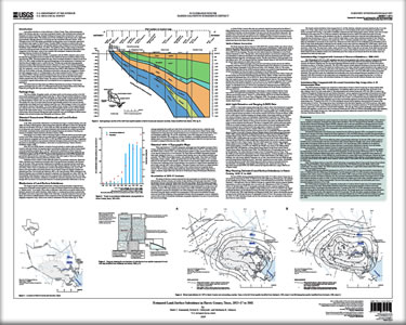
Land-surface subsidence, or land subsidence, in Harris County, Texas, which encompasses much of the Houston area, has been occurring for decades. Land subsidence has increased the frequency and extent of flooding, damaged buildings and transportation infrastructure, and caused adverse environmental effects. The primary cause of land subsidence in the Houston area is withdrawal of groundwater, although extraction of oil and gas also has contributed. Throughout most of the 20th century, groundwater was the primary source of municipal, agricultural, and industrial water supply for Harris County. Currently (2009) a transition to surface water as the primary source of supply, guided by a groundwater regulatory plan developed by the Harris-Galveston Subsidence District (2001), is in effect. The aquifers in Harris County contain an abundant amount of potable groundwater, but they also contain layers of clay. Groundwater withdrawals caused compaction of the clay layers, which in turn resulted in the widespread, substantial land-surface subsidence that has occurred in the Houston area. |
First posted December 31, 2009
For additional information contact: Part or all of this report is presented in Portable Document Format (PDF); the latest version of Adobe Reader or similar software is required to view it. Download the latest version of Adobe Reader, free of charge. |
Kasmarek, M.C., Gabrysch, R.K., and Johnson, M.R., 2009, Estimated land-surface subsidence in Harris County, Texas, 1915–17 to 2001: U.S. Geological Survey Scientific Investigations Map 3097, 2 sheets.
Introduction
Hydrogeology
Historical Groundwater Withdrawals and Land-Surface Subsidence
Mechanisms of Land-Surface Subsidence
Historical 1915–17 Topographic Maps
2001 Light Detection and Ranging (LiDAR) Data
Map Showing Estimated Land-Surface Subsidence in Harris County, 1915–17 to 2001
Summary
Selected References

![]() U.S. Department of the Interior |
U.S. Geological Survey
U.S. Department of the Interior |
U.S. Geological Survey
URL: http://pubsdata.usgs.gov/pubs/sim/3097/index.html
Page Contact Information: GS Pubs Web Contact
Page Last Modified: Thursday, 01-Dec-2016 17:18:06 EST
