Scientific Investigations Map 3101
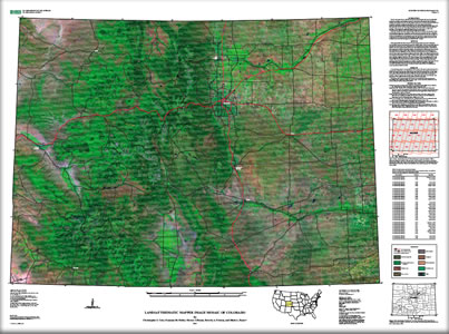
The U.S. Geological Survey (USGS) Rocky Mountain Geographic Science Center (RMGSC) produced a seamless, cloud-minimized remotely-sensed image spanning the State of Colorado. Multiple orthorectified Landsat 5 Thematic Mapper (TM) scenes collected during 2006–2008 were spectrally normalized via reflectance transformation and linear regression based upon pseudo-invariant features (PIFS) following the removal of clouds. Individual Landsat scenes were then mosaicked to form a six-band image composite spanning the visible to shortwave infrared spectrum. This image mosaic, presented here, will also be used to create a conifer health classification for Colorado in Scientific Investigations Map 3103. An archive of past and current Landsat imagery exists and is available to the scientific community (http://glovis.usgs.gov/), but significant pre-processing was required to produce a statewide mosaic from this information. Much of the data contained perennial cloud cover that complicated analysis and classification efforts. Existing Landsat mosaic products, typically three band image composites, did not include the full suite of multispectral information necessary to produce this assessment, and were derived using data collected in 2001 or earlier. A six-band image mosaic covering Colorado was produced. This mosaic includes blue (band 1), green (band 2), red (band 3), near infrared (band 4), and shortwave infrared information (bands 5 and 7). The image composite shown here displays three of the Landsat bands (7, 4, and 2), which are sensitive to the shortwave infrared, near infrared, and green ranges of the electromagnetic spectrum. Vegetation appears green in this image, while water looks black, and unforested areas appear pink. The lines that may be visible in the on-screen version of the PDF are an artifact of the export methods used to create this file. The file should be viewed at 150 percent zoom or greater for optimum viewing. |
First posted January 22, 2010
For additional information contact: Part or all of this report is presented in Portable Document Format (PDF); the latest version of Adobe Reader or similar software is required to view it. Download the latest version of Adobe Reader, free of charge. |
Cole, C.J., Noble, S.M., Blauer, S.L., Friesen, B.A., and Bauer, M.A., 2010, Landsat Thematic Mapper image mosaic of Colorado: U.S. Geological Survey Scientific Investigations Map 3101, scale 1:650,000, 1 sheet.

![]() U.S. Department of the Interior |
U.S. Geological Survey
U.S. Department of the Interior |
U.S. Geological Survey
URL: http://pubsdata.usgs.gov/pubs/sim/3101/index.html
Page Contact Information: GS Pubs Web Contact
Page Last Modified: Thursday, 01-Dec-2016 17:18:15 EST
