Scientific Investigations Map 3114
1U.S. Geological Survey, Box 25046, Mail Stop 966, Denver, CO 80225.
2Alaska Division of Geological and Geophysical Surveys, Fairbanks, AK 99709.
(now at: Alaska Division of Mining Land and Water, Fairbanks, AK 99709).
3Department of Geology and Geophysics, University of Alaska, Fairbanks, AK 99775.
4Department of Geological Sciences, San Diego State University, San Diego, CA 92182.
5Department of Geological Sciences, University of Oregon, Eugene, OR 97403.
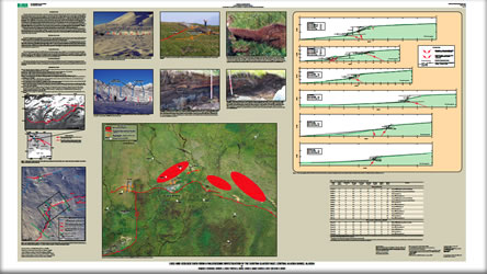
This report contains field and laboratory data from a paleoseismic study of the Susitna Glacier fault, Alaska. The initial M 7.2 subevent of the November 3, 2002, M 7.9 Denali fault earthquake sequence produced a 48-km-long set of complex fault scarps, folds, and aligned landslides on the previously unknown, north-dipping Susitna Glacier thrust fault along the southern margin of the Alaska Range in central Alaska. Most of the 2002 folds and fault scarps are 1–3 m high, implying dip-slip thrust offsets (assuming a near-surface fault dip of ≈20°) of 3–5 m. Locally, some of the 2002 ruptures were superimposed on preexisting scarps that have as much as 5–10 m of vertical separation and are evidence of previous surface-rupturing earthquakes on the Susitna Glacier fault. In 2003–2005, we focused follow-up studies on several of the large scarps at the “Wet fan” site in the central part of the 2002 rupture to determine the pre-2002 history of large surface-rupturing earthquakes on the fault. We chose this site for several reasons: (1) the presence of pre-2002 thrust- and normal-fault scarps on a gently sloping, post-glacial alluvial fan; (2) nearby natural exposures of underlying fan sediments revealed fine-grained fluvial silts with peat layers and volcanic ash beds useful for chronological control; and (3) a lack of permafrost to a depth of more than 1 m. Our studies included detailed mapping, fault-scarp profiling, and logging of three hand-excavated trenches. We were forced to restrict our excavations to 1- to 2-m-high splay faults and folds because the primary 2002 ruptures mostly were superimposed on such large scarps that it was impossible to hand dig through the hanging wall to expose the fault plane. Additional complications are the pervasive effects of cryogenic processes (mainly solifluction) that can mask or mimic tectonic deformation. The purpose of this report is to present photomosaics, trench logs, scarp profiles, and fault slip, radiocarbon, tephrochronologic, and unit description data obtained during this investigation. We do not attempt to use the data presented herein to construct a paleoseismic history of the Susitna Glacier fault; that history will be the subject of a future report. When completed, our results will be used to compare the Susitna Glacier fault paleoseismic record with results of similar studies on the nearby Denali fault to determine if the simultaneous rupture of these two faults during the 2002 Denali fault earthquake sequence is typical or atypical of their long-term interaction. |
First posted March 25, 2010 For additional information contact: Part or all of this report is presented in Portable Document Format (PDF); the latest version of Adobe Reader or similar software is required to view it. Download the latest version of Adobe Reader, free of charge. |
Personius, S.F., Crone, A.J., Burns, P.A., Begét, J.E., Seitz, G.G., and Bemis, S.P., 2010, Logs and geologic data from a paleoseismic investigation of the Susitna Glacier fault, central Alaska Range, Alaska: U.S. Geological Survey Scientific Investigations Map 3114, 2 sheets.

![]() U.S. Department of the Interior |
U.S. Geological Survey
U.S. Department of the Interior |
U.S. Geological Survey
URL: http://pubsdata.usgs.gov/pubs/sim/3114/index.html
Page Contact Information: GS Pubs Web Contact
Page Last Modified: Thursday, 01-Dec-2016 17:18:48 EST
