Scientific Investigations Map 3139
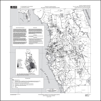
ABSTRACTThe Floridan aquifer system consists of the Upper and Lower Floridan aquifers separated by the middle confining unit. The middle confining unit and the Lower Floridan aquifer in west-central Florida generally contain highly mineralized water. The water-bearing units containing fresh water are herein referred to as the Upper Floridan aquifer. The Upper Floridan aquifer is the principal source of water in the Southwest Florida Water Management District and is used for major public supply, domestic use, irrigation, and brackish water desalination in coastal communities (Southwest Florida Water Management District, 2000). This map report shows the potentiometric surface of the Upper Floridan aquifer measured in May 2010. The potentiometric surface is an imaginary surface connecting points of equal altitude to which water will rise in tightly-cased wells that tap a confined aquifer system (Lohman, 1979). This map represents water-level conditions near the end of the dry season, when groundwater levels usually are at an annual low and withdrawals for agricultural use typically are high. The cumulative average rainfall of 55.21 inches for west-central Florida (from June 2009 through May 2010) was 2.55 inches above the historical cumulative average of 52.66 inches (Southwest Florida Water Management District, 2010). Historical cumulative averages are calculated from regional rainfall summary reports (1915 to most recent complete calendar year) and are updated monthly by the Southwest Florida Water Management District. This report, prepared by the U.S. Geological Survey in cooperation with the Southwest Florida Water Management District, is part of a semi-annual series of Upper Floridan aquifer potentiometric-surface map reports for west-central Florida. Potentiometric-surface maps have been prepared for January 1964, May 1969, May 1971, May 1973, May 1974, and for each May and September since 1975. Water-level data are collected in May and September each year to show the approximate annual low and high water-level conditions, respectively. Most of the water-level data for this map were collected by the U.S. Geological Survey during the period May 17-21, 2010. Supplemental water-level data were collected by other agencies and companies. Most water-level measurements were made during a 5-day period; therefore, measurements do not represent a "snapshot" of conditions at a specific time, nor do they necessarily coincide with the seasonal low water-level condition. |
First posted November 8, 2010
For additional information contact: Part or all of this report is presented in Portable Document Format (PDF); the latest version of Adobe Reader or similar software is required to view it. Download the latest version of Adobe Reader, free of charge. |
Ortiz, A.G., 2010, Potentiometric surface of the Upper Floridan aquifer, west-central Florida, May 2010: U.S. Geological Survey Scientific Investigations Map 3139, 1 sheet.

![]() U.S. Department of the Interior |
U.S. Geological Survey
U.S. Department of the Interior |
U.S. Geological Survey
URL: http://pubsdata.usgs.gov/pubs/sim/3139/index.html
Page Contact Information: USGS Publications Team
Page Last Modified: Thursday, 01-Dec-2016 17:20:39 EST
