 Abstract Abstract
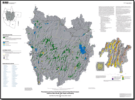
Increasing water use and changing climate in the Great Basin of the western United States are likely affecting the distribution of phreatophytic vegetation in the region. Phreatophytic plant communities that depend on groundwater are susceptible to natural and anthropogenic changes to hydrologic flow systems. The purpose of this report is to document the methods used to create the accompanying map that delineates areas of the Great Basin that have the greatest potential to support phreatophytic vegetation. Several data sets were used to develop the data displayed on the map, including Shrub Map (a land-cover data set derived from the Regional Gap Analysis Program) and Gap Analysis Program (GAP) data sets for California and Wyoming. In addition, the analysis used the surface landforms from the U.S. Geological Survey (USGS) Global Ecosystems Mapping Project data to delineate regions of the study area based on topographic relief that are most favorable to support phreatophytic vegetation. Using spatial analysis techniques in a GIS, phreatophytic vegetation classes identified within Shrub Map and GAP were selected and compared to the spatial distribution of selected landforms in the study area to delineate areas of phreatophyte vegetation. Results were compared to more detailed studies conducted in selected areas. A general qualitative description of the data and the limitations of the base data determined that these results provide a regional overview but are not intended for localized studies or as a substitute for detailed field analysis. The map is intended as a decision-support aide for land managers to better understand, anticipate, and respond to ecosystem changes in the Great Basin.
|
-
This report is available only on the Web.
This report is presented in Portable Document Format (PDF); the latest version of Adobe Reader or similar software is required to view it. Download the latest version of Adobe Reader, free of charge. |

