Skip Links

USGS - science for a changing world

Scientific Investigations Map 3202

Prepared in cooperation with the Dolores Water Conservancy District

Bathymetry of Groundhog Reservoir, Dolores County, Colorado, 2011

By Michael S. Kohn

Thumbnail of and link to publicationAbstract

In order to better characterize the water supply capacity of Groundhog Reservoir, Dolores County, Colorado, the U.S. Geological Survey, in cooperation with the Dolores Water Conservancy District, conducted a bathymetric survey of Groundhog Reservoir. The study was performed in June 2011 using a man-operated boat-mounted multibeam echo sounder integrated with a global positioning system and a terrestrial real-time kinematic global positioning system. The two collected datasets were merged and imported into geographic information system software. A bathymetric map of the reservoir was generated in addition to plots for the stage-area and the stage-volume relations.

Revised April 17, 2012
First posted March 14, 2012

For additional information:
USGS Colorado Water Science Center
Box 25046, Mail Stop 415
Denver, CO 80225-0046
co.water.usgs.gov

This report is presented in Portable Document Format (PDF); the latest version of Adobe Reader or similar software is required to view it. Download the latest version of Adobe Reader, free of charge.


Suggested citation:

Kohn, M.S., 2012, Bathymetry of Groundhog Reservoir, Dolores County, Colorado, 2011: U.S. Geological Survey Scientific Investigations Map 3202, scale 1:8,000 [https://pubs.usgs.gov/sim/3202/].


Contents

Abstract

Introduction

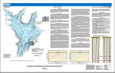
Bathymetric Measurement and Storage Analysis

Summary

Acknowledgments

References Cited


Accessibility FOIA Privacy Policies and Notices

Take Pride in America logo USA.gov logo U.S. Department of the Interior | U.S. Geological Survey
URL: http://pubsdata.usgs.gov/pubs/sim/3202/index.html
Page Contact Information: GS Pubs Web Contact
Page Last Modified: Tuesday, 24-Oct-2017 11:08:13 EDT