Scientific Investigations Map 3204
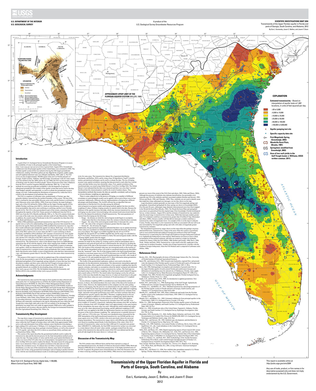
AbstractThe Floridan aquifer system (FAS) covers an area of approximately 100,000 square miles in Florida and parts of Georgia, South Carolina, Alabama, and Mississippi. Groundwater wells for water supply were first drilled in the late 1800s and by the year 2000, the FAS was the primary source of drinking water for about 10 million people. One of the methods for assessing groundwater availability is the development of regional or subregional groundwater flow models of the aquifer system that can be used to develop water budgets spatially and temporally, as well as evaluate the groundwater resource change over time. Understanding the distribution of transmissivity within the FAS is critical to the development of groundwater flow models. The map presented herein differs from previously published maps of the FAS in that it is based on interpolation of 1,487 values of transmissivity. The transmissivity values in the dataset range from 8 to 9,000,000 feet squared per day (ft2/d) with the majority of the values ranging from 10,000 to 100,000 ft2/d. The wide range in transmissivity (6 orders of magnitude) is typical of carbonate rock aquifers, which are characterized by a wide range in karstification. Commonly, the range in transmissivity is greatest in areas where groundwater flow creates conduits in facies that dissolve more readily or areas of high porosity units that have interconnected vugs, with diameters greater than 0.1 foot. These are also areas where transmissivity is largest. Additionally, first magnitude springsheds and springs are shown because in these springshed areas, the estimates of transmissivity from interpolation may underestimate the actual range in transmissivity. Also shown is an area within the Gulf Trough in Georgia where high yielding wells are unlikely to be developed in the Upper Floridan aquifer. The interpolated transmissivity ranges shown on this map reflect the geologic structure and karstified areas. Transmissivity is large in the areas where the system is unconfined, such as west-central Florida and southwest Georgia just northwest of the Gulf Trough. Transmissivity is small along the Gulf Trough and Southwest Georgia Embayment (referred to as Apalachicola Embayment in some reports). Transmissivity is also small in the thin, updip part of the system near its northern boundary. Another area of large transmissivity coincides with the Southeast Georgia Embayment. |
Posted April 19, 2012
For additional information contact: Part or all of this report is presented in Portable Document Format (PDF); the latest version of Adobe Reader or similar software is required to view it. Download the latest version of Adobe Reader, free of charge. |
Kuniansky, E.L., Bellino, J.C., and Dixon, J.F., 2012, Transmissivity of the Upper Floridan aquifer in Florida and parts of Georgia, South Carolina, and Alabama: U.S. Geological Survey Scientific Investigations Map 3204, 1 sheet, scale 1:100,000, available only at https://pubs.usgs.gov/sim/3204.
Introduction
Acknowledgments
Transmissivity Map Development
Discussion of the Transmissivity Map
References Cited

![]() U.S. Department of the Interior |
U.S. Geological Survey
U.S. Department of the Interior |
U.S. Geological Survey
URL: http://pubsdata.usgs.gov/pubs/sim/3204/index.html
Page Contact Information: GS Pubs Web Contact
Page Last Modified: Thursday, 01-Dec-2016 17:25:22 EST
