Scientific Investigations Map 3207
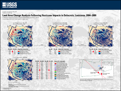
AbstractThe purpose of this project is to provide improved estimates of Louisiana wetland land loss due to hurricane impacts between 2004 and 2009 based upon a change detection mapping analysis that incorporates pre- and post-landfall (Hurricanes Katrina, Rita, Gustav, and Ike) fractional water classification of a combination of high resolution (QuickBird, IKONOS and Geoeye-1) and medium resolution (Landsat) satellite imagery. This second dataset focuses on Hurricanes Katrina and Gustav, which made landfall on August 29, 2005, and September 1, 2008, respectively. The study area is an approximately 1208-square-kilometer region surrounding Delacroix, Louisiana, in the eastern Delta Plain. Overall, 77 percent of the area remained unchanged between 2004 and 2009, and over 11 percent of the area was changed permanently by Hurricane Katrina (including both land gain and loss). Less than 3 percent was affected, either temporarily or permanently, by Hurricane Gustav. A related dataset (SIM 3141) focused on Hurricane Rita, which made landfall on the Louisiana/Texas border on September 24, 2005, as a Category 3 hurricane. |
First posted May 30, 2012
For additional information contact: Part or all of this report is presented in Portable Document Format (PDF); the latest version of Adobe Reader or similar software is required to view it. Download the latest version of Adobe Reader, free of charge. |
Palaseanu-Lovejoy, M.E., Kranenburg, C.J., and Brock, J.C., 2012, Land area change analysis following hurricane impacts in Delacroix, Louisiana, 2004–2009, U.S. Geological Survey Scientific Investigations Map 3207, 1 sheet plus 9 p. pamphlet.

![]() U.S. Department of the Interior |
U.S. Geological Survey
U.S. Department of the Interior |
U.S. Geological Survey
URL: http://pubsdata.usgs.gov/pubs/sim/3207/index.html
Page Contact Information: GS Pubs Web Contact
Page Last Modified: Thursday, 01-Dec-2016 17:26:04 EST
