 Abstract Abstract
The part of the Equus Beds aquifer in southwestern Harvey County and northwestern Sedgwick County was developed to supply water to the city of Wichita and for irrigation in south-central Kansas. The 165 square-mile study area represents about 12 percent of the 1,400 square-mile Equus Beds aquifer and accounts for about one-third of the withdrawals from the aquifer. Water-level and storage-volume decreases that began with the development of the aquifer in the 1940s reached record to near-record lows in January 1993. Since 1993, generally higher water levels and partial storage-volume recoveries have been recorded in the aquifer.
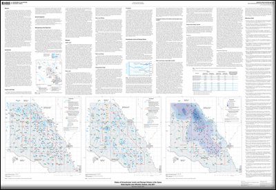
Potentiometric maps of the shallow and deep layers of the aquifer show flow in both aquifer layers is generally from west to east. The July 2011 water-level altitudes in the shallow aquifer layer ranged from a high of about 1,470 feet in the northwest corner of the study area to a low of about 1,330 feet in the southeast corner of the study area; water-level altitudes in the deep aquifer layer ranged from a high of about 1,445 feet on the west edge of the study area to a low of about 1,340 feet in the southeast corner of the study area. In the northwest part of the study area, water-levels can be more than 60 feet higher in the shallow layer than in the deep layer of the Equus Beds aquifer. Measured water-level changes for August 1940 to July 2011 ranged from a decline of 43.22 feet to a decline of 0.17 feet and averaged 12.45 feet. The largest August 1940 to July 2011 water-level changes of 30 feet or more occurred in the northern part of the study area centered about 2 and 4 miles east of Burrton, Kansas.
The change in storage volume from August 1940 to July 2011 in the study area was a decrease of about 209,000 acre-feet. This volume represents a recovery of about 46,000 acre-feet, or only about 18 percent of the storage volume previously lost between August 1940 and January 1993. The largest post-1993 storage-volume recovery to date in the study area was about 161,300 acre-feet in July 2010. The approximately 115,000 acre-feet decrease in storage volume from July 2010 to July 2011 in the study area represents a depletion of about 71 percent of storage volume previously recovered from January 1993 to July 2010; about 105,000 acre-feet of this decrease occurred between January and July 2011. Most of this depletion probably is because of decreased recharge from precipitation that at 9.26 inches for January through July 2011 was less than one-half of normal and increased irrigation pumpage associated with less-than-normal precipitation; city pumpage probably was less than average. For the study area, irrigation pumpage for 2011 was estimated at about 42,700 acre-feet and 2011 city pumpage was estimated at about 21,400 acre-feet.
The approximately 29,900 acre-feet decrease in storage volume from July 2010 to July 2011 in the central part of the study area represents a depletion of about 31 percent of the storage volume previously recovered from January 1993 to July 2010. A major factor in the greater percentage retention of the January 1993 to July 2010 recovery in the central part of the study area is the decreased city pumpage as part of Wichita’s Integrated Local Water Supply Plan.
|
Part or all of this report is presented in Portable Document Format (PDF); the latest version of Adobe Reader or similar software is required to view it. Download the latest version of Adobe Reader, free of charge. |

