Skip Links

USGS - science for a changing world

U.S. Geological Survey Scientific Investigations Map 3212

Paleoseismology of a Newly Discovered Scarp in the Yakima Fold-and-Thrust Belt, Kittitas County, Washington

By Elizabeth A. Barnett, Brian L. Sherrod, Robert Norris, and Douglas Gibbons

Thumbnail of and link to report PDF (24.3 MB)Summary

The Boylston Mountains anticlinal ridge is one of several that are cored by rocks of the Columbia River Basalt Group and, with the interceding synclinal valleys, constitute the Yakima fold-and-thrust belt of central Washington. Lidar data acquired from the U.S. Army’s Yakima Training Center reveal a prominent, northwest-side-up, 65°- to 70°-trending, 3- to 4-meter-high scarp that cuts across the western end of the Boylston Mountains, perpendicular to the mapped anticline. The scarp continues to the northeast from the ridge on the southern side of Park Creek and across the low ridges for a total length of about 3 kilometers. A small stream deeply incises its flood plain where it projects across Johnson Canyon.

The scarp is inferred to be late Quaternary in age based on its presence on the modern landscape and the incised flood-plain sediments in Johnson Canyon. Two trenches were excavated across this scarp. The most informative of the two, the Horned Lizard trench, exposed shallow, 15.5-Ma Grande Ronde Basalt, which is split by a deep, wide crack that is coincident with the base of the scarp and filled with wedges of silty gravels that are interpreted to represent at least two generations of fault colluvium that offset a buried soil.

First posted February 14, 2013

  • This report is available only on the Web.

For additional information:
Contact Information, Earthquake Science Center, Seattle, Washington Field Office
U.S. Geological Survey
Dept. Earth & Space Sciences
University of Washington, Box 351310
Seattle, WA 98195-1310
http://earthquake.usgs.gov/

This report is presented in Portable Document Format (PDF); the latest version of Adobe Reader or similar software is required to view it. Download the latest version of Adobe Reader, free of charge.


Suggested citation:

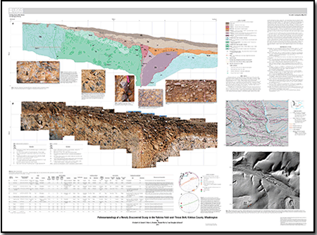
Barnett, E.A., Sherrod, B.L., Norris, Robert, and Gibbons, Douglas, 2013, Paleoseismology of a newly discovered scarp in the Yakima fold-and-thrust belt, Kittitas County, Washington: U.S. Geological Survey Scientific Investigations Map 3212. (Available at https://pubs.usgs.gov/sim/3212.)


Accessibility FOIA Privacy Policies and Notices

Take Pride in America logo USA.gov logo U.S. Department of the Interior | U.S. Geological Survey
URL: http://pubsdata.usgs.gov/pubs/sim/3212/index.html
Page Contact Information: GS Pubs Web Contact
Page Last Modified: Thursday, 01-Dec-2016 17:28:46 EST