Scientific Investigations Map 3217
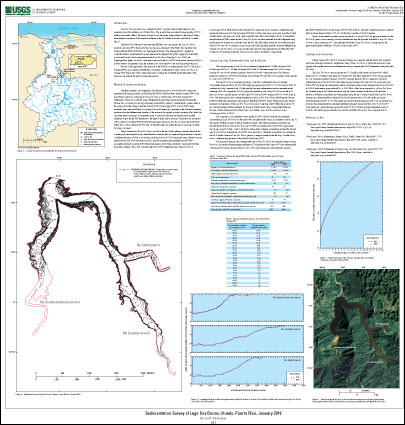
IntroductionLago Dos Bocas reservoir was completed in 1942 to provide water for hydroelectric power generation along the northern coast of Puerto Rico. The reservoir had an original storage capacity of 37.50 million cubic meters (Mm3). The dam is located about 9 kilometers (km) northeast of the town of Utuado, immediately downstream of the original confluence of the Río Grande de Arecibo and the Río Caonillas (fig. 1). The Puerto Rico Electric Power Authority (PREPA) owns and operates the Lago Dos Bocas reservoir, and since 1996, the reservoir has become an essential part of the Puerto Rico Aqueduct and Sewer Authority (PRASA) North Coast Superaqueduct Project. The Superaqueduct is supplied by controlled releases for hydroelectric power generation that replenish the public-supply raw-water intake pool located about 10 km downstream from the Lago Dos Bocas Dam (fig. 1). As of 2005, the Superaqueduct supplies about 4.03 cubic meters per second (m3/s) (348,192 cubic meters per day [m3/d]) of potable water to communities along the northern coast, from Arecibo to the San Juan metropolitan area. Because of the importance of the reservoir to the North Coast Superaqueduct, the U.S. Geological Survey (USGS), in cooperation with PRASA, conducted a sedimentation survey of Lago Dos Bocas in January 2009. The results of this survey were used to estimate the useful life and the firm yield of the reservoir, and evaluate the need to dredge the reservoir. |
First posted December 13, 2012
For additional information contact: Part or all of this report is presented in Portable Document Format (PDF); the latest version of Adobe Reader or similar software is required to view it. Download the latest version of Adobe Reader, free of charge. |
Soler-López, L.R., 2012, Sedimentation survey of Lago Dos Bocas, Utuado, Puerto Rico, January 2010: U.S. Geological Survey Scientific Investigations Map 3217, 1 sheet, available at https://pubs.usgs.gov/sim/3217/.

![]() U.S. Department of the Interior |
U.S. Geological Survey
U.S. Department of the Interior |
U.S. Geological Survey
URL: http://pubsdata.usgs.gov/pubs/sim/3217/index.html
Page Contact Information: GS Pubs Web Contact
Page Last Modified: Thursday, 01-Dec-2016 17:28:07 EST
