 Summary Summary
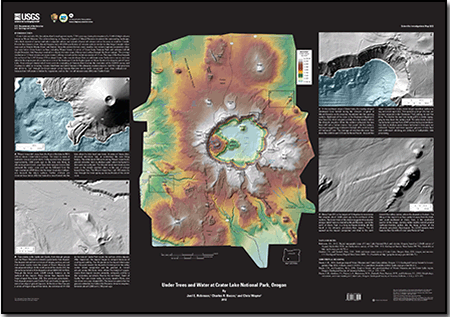
Crater Lake partially fills the caldera that formed approximately 7,700 years ago during the eruption of a 12,000-ft-high volcano known as Mount Mazama. The caldera-forming, or climactic, eruption of Mount Mazama devastated the surrounding landscape, left a thick deposit of pumice and ash in adjacent valleys, and spread a blanket of volcanic ash as far away as southern Canada. Prior to the climactic event, Mount Mazama had a 400,000-year history of volcanic activity similar to other large Cascade volcanoes such as Mounts Shasta, Hood, and Rainier. Since the caldera formed, many smaller, less violent eruptions occurred at volcanic vents below Crater Lake’s surface, including Wizard Island. A survey of Crater Lake National Park with airborne LiDAR (Light Detection And Ranging) resulted in a digital elevation map of the ground surface beneath the forest canopy. The average resolution is 1.6 laser returns per square meter yielding vertical and horizontal accuracies of ±5 cm. The map of the floor beneath the surface of the 1,947-ft-deep (593-m-deep) Crater Lake was developed from a multibeam sonar bathymetric survey and was added to the map to provide a continuous view of the landscape from the highest peak on Mount Scott to the deepest part of Crater Lake. Four enlarged shaded-relief views provide a sampling of features that illustrate the resolution of the LiDAR survey and illustrate its utility in revealing volcanic landforms and subtle features of the climactic eruption deposits. LiDAR’s high precision and ability to “see” through the forest canopy reveal features that may not be easily recognized—even when walked over—because their full extent is hidden by vegetation, such as the 1-m-tall arcuate scarp near Castle Creek.
|
See also:
- DS 716, High-Resolution Digital Elevation Dataset for Crater Lake National Park and Vicinity, Oregon, based on LiDAR Survey of August-September 2010 and Bathymetric Survey of July 2000
- DDS–72, 2000 Multibeam sonar survey of Crater Lake, Oregon - Data, GIS, images, and movies
-
This report is also available in print from:
USGS Information Services, Box 25286,
Federal Center, Denver, CO 80225
telephone: 888 ASK-USGS; e-mail: infoservices@usgs.gov
This report is presented in Portable Document Format (PDF); the latest version of Adobe Reader or similar software is required to view it. Download the latest version of Adobe Reader, free of charge. |

