Scientific Investigations Map 3238
|
First posted August 5, 2013 Files for viewing and printing:Data:
For additional information: Part of this report is presented in Portable Document Format (PDF); the latest version of Adobe Reader or similar software is required to view it. Download the latest version of Adobe Reader, free of charge. |
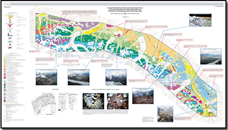
Nokleberg, W.J., Aleinikoff, J.H., Bundtzen, T.K., and Hanshaw, M.N., 2013, Geologic strip map along the Hines Creek Fault showing evidence for Cenozoic displacement in the western Mount Hayes and northeastern Healy quadrangles, eastern Alaska Range, Alaska: U.S. Geological Survey Scientific Investigations Map 3238, pamphlet 31 p., scale 1:63,360, and GIS data, https://pubs.usgs.gov/sim/3238/.

![]() U.S. Department of the Interior |
U.S. Geological Survey
U.S. Department of the Interior |
U.S. Geological Survey
URL: http://pubsdata.usgs.gov/pubs/sim/3238/index.html
Page Contact Information: GS Pubs Web Contact
Page Last Modified: Thursday, 01-Dec-2016 17:30:40 EST