 Summary Summary
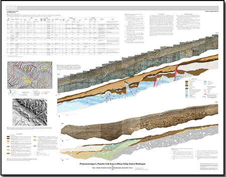
In October 2009, two trenches excavated across an 11-kilometer-long scarp at Wenas Valley in central Washington exposed evidence for late Quaternary deformation. Lidar imagery of the Wenas Valley illuminated the west-northwest-trending, 2- to 8-meter-high scarp as it bisected alluvial fans developed at the mouths of canyons along the south side of Umtanum Ridge. The alignment of the scarp and aeromagnetic lineaments suggested that the scarp may be a product of and controlled by the same tectonic structure that produced the magnetic lineaments. Several large landslides mapped in the area demonstrated the potential for large mass-wasting events in the area. In order to test whether the scarp was the result of an earthquake-generated surface rupture or a landslide, trenches were excavated at Hessler Flats and McCabe Place. The profiles of bedrock and soil stratigraphy that underlie the scarp in each trench were photographed, mapped, and described, and a sequence of depositional and deformational events established for each trench.
The McCabe Place trench exposed a sequence of volcaniclastic deposits overlain by soils and alluvial deposits separated by three unconformities. Six normal faults and two possible reverse faults deformed the exposed strata. Crosscutting relations indicated that up to five earthquakes occurred on a blind reverse fault, and a microprobe analysis of lapilli suggested that the earliest faulting occurred after 47,000 years before present. The Hessler Flat trench exposure revealed weathered bedrock that abuts loess and colluvium deposits and is overlain by soil, an upper sequence of loess, and colluvium. The latter two units bury a distinctive paloesol.
|
First posted March 29, 2013
-
This report is available only on the Web.
This report is presented in Portable Document Format (PDF); the latest version of Adobe Reader or similar software is required to view it. Download the latest version of Adobe Reader, free of charge. |

